IMAGES TAKEN NEAR TO
Longmead Avenue, BRISTOL, BS7 8QB
Introduction
This page details the photographs taken nearby to Longmead Avenue, BS7 8QB by members of the Geograph project.
The Geograph project started in 2005 with the aim of publishing, organising and preserving representative images for every square kilometre of Great Britain, Ireland and the Isle of Man.

There are currently over 7.5m images from over14,400 individuals and you can help contribute to the project by visiting https://www.geograph.org.uk
Image Map
Images are licensed for reuse under creativecommons.org/licenses/by-sa/2.0
Notes
- Clicking on the map will re-center to the selected point.
- The higher the marker number, the further away the image location is from the centre of the postcode.
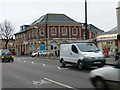
Image Listing (69 Images Found)
Images are licensed for reuse under creativecommons.org/licenses/by-sa/2.0
Image
Details
Distance
1
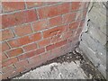
Ordnance Survey Cut Mark
This OS cut mark can be found on the prison wall on Longmead Avenue. It marks a point 56.879m above mean sea level.
Image: © Adrian Dust
Taken: 1 Jul 2022
0.02 miles
2
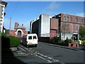
Horfield Prison
Horfield Prison, Bristol
Image: © Kate Lambert
Taken: 18 Apr 2005
0.02 miles
3
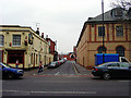
Looking up Cambridge Road to Horfield Prison
Standing on the Gloucester Road looking north-west to the original entrance of Horfield Prison.
Image: © Linda Bailey
Taken: 23 Feb 2006
0.04 miles
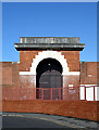
4
H M Prison, Bristol
Formidable entry gateway to Bristol's prison, on Cambridge Road
Image: © Eirian Evans
Taken: 25 Aug 2012
0.06 miles
5
Old Gate at Horfield Prison
I assume that in the past this was used as the main gateway into the prison, now a modern concrete block serves as this function.
The gate can be seen from a distance in Image
Image: © Linda Bailey
Taken: 29 Mar 2007
0.06 miles
6
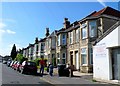
Radnor Rd
This is the eastern end of Radnor Rd looking west. There is another Radnor Rd only a few streets away so it must be confusing for postie.
Image: © Nigel Mykura
Taken: 12 Jun 2010
0.06 miles
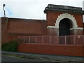
7
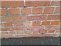
Ordnance Survey Cut Mark
This OS cut mark can be found on the prison wall on Cambridge Road. It marks a point 56.147m above mean sea level.
Image: © Adrian Dust
Taken: 1 Jul 2022
0.07 miles
8

Falmouth Road, Bishopston
With the walls of HMP Bristol at the far end
Image: © Eirian Evans
Taken: 3 Sep 2021
0.07 miles
9
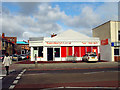
Brand New Sainsbury's, Bishopston
This has only just opened, and now this area has: Sainsbury's Local, Tesco Metro, Tesco, Somerfield and Co-op within a very short space of each other. In the distance the blue roof is the prison having some repairs carried out.
Image: © Linda Bailey
Taken: 28 Mar 2006
0.07 miles
10
Main road into Bristol from the east
The A38 near its junction with Longmead Avenue
Image: © Eirian Evans
Taken: 23 Mar 2010
0.08 miles