IMAGES TAKEN NEAR TO
Princes Place, BRISTOL, BS7 8NS
Introduction
This page details the photographs taken nearby to Princes Place, BS7 8NS by members of the Geograph project.
The Geograph project started in 2005 with the aim of publishing, organising and preserving representative images for every square kilometre of Great Britain, Ireland and the Isle of Man.

There are currently over 7.5m images from over14,400 individuals and you can help contribute to the project by visiting https://www.geograph.org.uk
Image Map
Images are licensed for reuse under creativecommons.org/licenses/by-sa/2.0
Notes
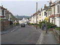
- Clicking on the map will re-center to the selected point.
- The higher the marker number, the further away the image location is from the centre of the postcode.
Image Listing (123 Images Found)
Images are licensed for reuse under creativecommons.org/licenses/by-sa/2.0
Image
Details
Distance
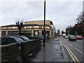
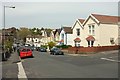
2
Princes Place, Bishopston
Attractive barge-boarded houses on this cul-de-sac off the Gloucester Road.
Image: © Derek Harper
Taken: 15 Nov 2013
0.04 miles
3
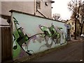
Mural, Princes Place, Bishopston
The title is "Whenphilosophersarekings". On the right is the Glouceter Road.
Image: © Derek Harper
Taken: 15 Nov 2013
0.06 miles
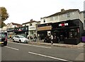
5
Oddbins, Gloucester Road
On the junction of Gloucester Road and Egerton Road.
Image: © Eirian Evans
Taken: 7 Jan 2011
0.07 miles
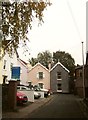
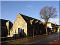
6
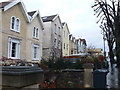
Houses on the A38, Gloucester Road, Ashley Down
Image: © Eirian Evans
Taken: 7 Jan 2011
0.07 miles
7
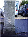
Benchmark on gatepost at entrance to #120 Gloucester Road
Ordnance Survey cut mark benchmark described on the Bench Mark Database at http://www.bench-marks.org.uk/bm35193.
Image: © Roger Templeman
Taken: 14 Aug 2010
0.08 miles
8
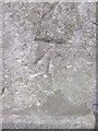
Ordnance Survey Cut Mark
This OS cut mark can be found on the gatepost of 120 Gloucester Road. It marks a point 41.139m above mean sea level.
Image: © Adrian Dust
Taken: 3 Mar 2016
0.08 miles
9
Sommerville Road, Bishopston
A crossroads with Belmont (left) and Upper Belmont Road as Sommerville Road drops to meet the Gloucester Road.
Image: © Derek Harper
Taken: 6 May 2016
0.09 miles
10
St Michael and All Angels Church Hall
This is now the church hall of St Michael and All Angels Church, but it was used for worship for about 3 years. The church was originally immediately behind the photographer but had lots of structural problems (subsidence), and was demolished after the church closed in 1991. For a full history see http://www.bishopstonandstandrews.org.uk/SMHistory.htm
Image: © Linda Bailey
Taken: 21 Nov 2006
0.09 miles