IMAGES TAKEN NEAR TO
Berkeley Road, BRISTOL, BS7 8HZ
Introduction
This page details the photographs taken nearby to Berkeley Road, BS7 8HZ by members of the Geograph project.
The Geograph project started in 2005 with the aim of publishing, organising and preserving representative images for every square kilometre of Great Britain, Ireland and the Isle of Man.

There are currently over 7.5m images from over14,400 individuals and you can help contribute to the project by visiting https://www.geograph.org.uk
Image Map (Loading...)


Getting Data...Please wait
Leaflet Map data © OpenStreetMap
Images are licensed for reuse under creativecommons.org/licenses/by-sa/2.0
Notes
- Clicking on the map will re-center to the selected point.
- The higher the marker number, the further away the image location is from the centre of the postcode.
Image Listing (105 Images Found)
Images are licensed for reuse under creativecommons.org/licenses/by-sa/2.0
Image
Details
Distance
1
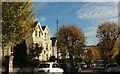
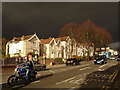
Berkeley Road, Bishopston
The tree-lined road descends to meet the Gloucester Road.
Image: © Derek Harper
Taken: 25 Oct 2017
0.02 miles
2
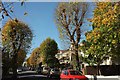
Berkeley Road, Bishopston
A reverse view of Image], with autumnal trees.
Image: © Derek Harper
Taken: 25 Oct 2017
0.02 miles
3
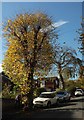
Berkeley Road, Bishopston
An autumnal tree on the south side of the road.
Image: © Derek Harper
Taken: 25 Oct 2017
0.03 miles
4
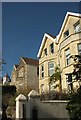
Houses on Berkeley Road, Bishopston
On the left is the tower seen in Image
Image: © Derek Harper
Taken: 25 Oct 2017
0.04 miles
5
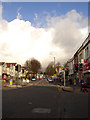
Houses on Pig Sty Hill
This part of the Gloucester Road is known as Pig Sty Hill locally, I assume that there was a pig farm here in the 19th century. Seen just immediately before an enormous hail storm.
Image: © Linda Bailey
Taken: 21 Nov 2006
0.05 miles
6
Pig Sty Hill, Bishopston
Looking up Pig Sty Hill, on the Gloucester Road towards an approaching storm. This is taken from the junction with Somerville Road.
Image: © Linda Bailey
Taken: 21 Nov 2006
0.05 miles
7
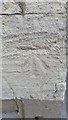
Ordnance Survey Cut Mark
This OS cut mark can be found on the former Methodist Chapel on Gloucester Road. Now 102 Gloucester Road, Nailsea Electrical. It marks a point 46.257m above mean sea level.
Image: © Adrian Dust
Taken: 29 Feb 2016
0.05 miles
8
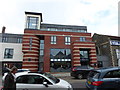
Bishopston Library
The new Bishopston Library opened May 2017, replacing the Cheltenham Road library
Image: © Eirian Evans
Taken: 19 Feb 2018
0.06 miles
9
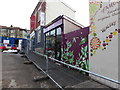
Wild Leaf, Overton Road
Small shop selling exotic plants. Buildings have been demolished on the opposite side of the road to make was for new housing, hence the barricades and portacabins in the road.
Image: © Eirian Evans
Taken: 19 Feb 2018
0.06 miles
10
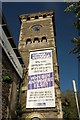
Tower on Gloucester Road, Bristol
The Italianate tower of a former Free Methodist Church http://churchdb.gukutils.org.uk/GLS1440.php . "The tower originally had a small spire on top, but this was removed in 1966". Now occupied, as the banner suggests, by Nailsea Electrical Appliances.
Image: © Derek Harper
Taken: 25 Oct 2017
0.06 miles