IMAGES TAKEN NEAR TO
Berkeley Road, BRISTOL, BS7 8HX
Introduction
This page details the photographs taken nearby to Berkeley Road, BS7 8HX by members of the Geograph project.
The Geograph project started in 2005 with the aim of publishing, organising and preserving representative images for every square kilometre of Great Britain, Ireland and the Isle of Man.

There are currently over 7.5m images from over14,400 individuals and you can help contribute to the project by visiting https://www.geograph.org.uk
Image Map (Loading...)


Getting Data...Please wait
Leaflet Map data © OpenStreetMap
Images are licensed for reuse under creativecommons.org/licenses/by-sa/2.0
Notes
- Clicking on the map will re-center to the selected point.
- The higher the marker number, the further away the image location is from the centre of the postcode.
Image Listing (62 Images Found)
Images are licensed for reuse under creativecommons.org/licenses/by-sa/2.0
Image
Details
Distance
1
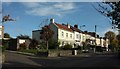
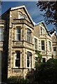
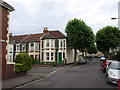
Berkeley Road, Bishopston
Variety in the age and style of houses along the north side of the tree-lined road. On the left is a glimpse of the much newer Colston Court.
Image: © Derek Harper
Taken: 25 Oct 2017
0.03 miles
2
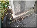
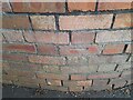
Ordnance Survey Pivot
This OS pivot can be found on the wall of No106 Edgerton Road. It marks a point 64.066m above mean sea level.
Image: © Adrian Dust
Taken: 1 Jul 2022
0.05 miles
3
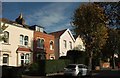
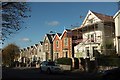
Houses on Berkeley Road, Bishopston
Just right of the scene in Image On the right is a postbox at the junction with Wentworth Road.
Image: © Derek Harper
Taken: 25 Oct 2017
0.05 miles
4
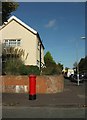
Postbox on Berkeley Road, Bishopston
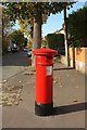
Postbox BS7 335 is at the corner with Wentworth Road. Would you believe I took four photos with this postbox in them and failed to take one showing the cypher?
Image: © Derek Harper
Taken: 25 Oct 2017
0.06 miles
5
Postbox on Berkeley Road, Bishopston
A different view of Image], looking along Berkeley Road.
Image: © Derek Harper
Taken: 25 Oct 2017
0.06 miles
6
Houses on Berkeley Road, Bishopston
Just east of the junction with Wentworth Road.
Image: © Derek Harper
Taken: 25 Oct 2017
0.07 miles
7
Ordnance Survey Cut Mark
This OS cut mark can be found on the wall of No42 Berkeley Road. It marks a point 62.277m above mean sea level.
Image: © Adrian Dust
Taken: 1 Jul 2022
0.07 miles
8
Berkeley Road, Bishopston
The terrace on the left is shown from the other direction in Image
Image: © Derek Harper
Taken: 25 Oct 2017
0.07 miles
9
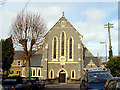
St Bonaventure's Church
The church foundation stone was laid on 14th July 1900 and the church was officially opened on 14th March 1901 by Bishop Brownlow.
Image: © Linda Bailey
Taken: 31 Mar 2006
0.08 miles
10
Junction of Dulverton Road and Cornwall Road, Bristol
Just hidden on the right is the junction with Beauchamp Road. This is in Bishopston, a pleasant residential part of the city.
Image: © Derek Harper
Taken: 10 Jul 2009
0.09 miles