IMAGES TAKEN NEAR TO
Codrington Road, BRISTOL, BS7 8ET
Introduction
This page details the photographs taken nearby to Codrington Road, BS7 8ET by members of the Geograph project.
The Geograph project started in 2005 with the aim of publishing, organising and preserving representative images for every square kilometre of Great Britain, Ireland and the Isle of Man.

There are currently over 7.5m images from over14,400 individuals and you can help contribute to the project by visiting https://www.geograph.org.uk
Image Map
Images are licensed for reuse under creativecommons.org/licenses/by-sa/2.0
Notes
- Clicking on the map will re-center to the selected point.
- The higher the marker number, the further away the image location is from the centre of the postcode.
Image Listing (147 Images Found)
Images are licensed for reuse under creativecommons.org/licenses/by-sa/2.0
Image
Details
Distance
1
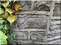
Ordnance Survey Cut Mark
This OS cut mark can be found on the wall south side of Shadwell Road. It marks a point 47.131m above mean sea level.
Image: © Adrian Dust
Taken: 1 Jul 2022
0.06 miles
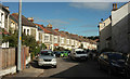
2
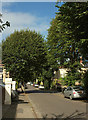
Tyne Road, Bishopston
Approaching the crossroads with Shadwell Road, about 30 metres ahead.
Image: © Derek Harper
Taken: 26 Sep 2018
0.07 miles
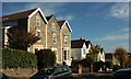
3
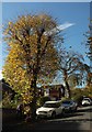
Berkeley Road, Bishopston
An autumnal tree on the south side of the road.
Image: © Derek Harper
Taken: 25 Oct 2017
0.07 miles
4
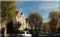
Berkeley Road, Bishopston
The tree-lined road descends to meet the Gloucester Road.
Image: © Derek Harper
Taken: 25 Oct 2017
0.08 miles
5
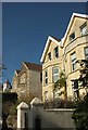
Houses on Berkeley Road, Bishopston
On the left is the tower seen in Image
Image: © Derek Harper
Taken: 25 Oct 2017
0.08 miles
6
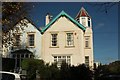
Houses on Berkeley Road, Bishopston
The house with the octagonal tower is at the corner of Arundel Road.
Image: © Derek Harper
Taken: 25 Oct 2017
0.09 miles
7
Berkeley Road, Bishopston
The house with the octagonal tower on the right is at the junction with Arundel Road.
Image: © Derek Harper
Taken: 25 Oct 2017
0.09 miles
8
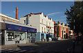
Gloucester Road, Bristol
The A38 passing the junction with Brookfield Avenue, between the estate agents (left) and the Bristol Flyer pub (centre). To the right is Bristol North Baths Image https://historicengland.org.uk/listing/the-list/list-entry/1187218 , which includes the chimney.
Image: © Derek Harper
Taken: 13 Sep 2019
0.09 miles
9
Wolseley Road, Bishopston
The central of three residential streets linking Tyne Road to the Gloucester Road, but the only one with a double bend like this.
Image: © Derek Harper
Taken: 26 Sep 2018
0.09 miles
10
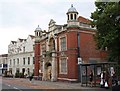
Bristol North Baths
On Gloucester Road, this impressive piece of "Edwardian Baroque" http://www.imagesofengland.org.uk/Details/Default.aspx?id=379606&mode=adv was built in 1912. "Red brick with limestone dressings ... Central portico with octagonal shafts to domed pinnacles flanking an elliptical-arched opening with square responds and a moulded archivolt ... A complete public baths with considerable architectural attention to both the front and inside." The baths, which featured in two episodes of "The Young Ones", have now closed, and their future, a matter of considerable local controversy, seems uncertain.
Next door is the Bristol Flyer pub.
Image: © Derek Harper
Taken: 10 Jul 2009
0.09 miles