IMAGES TAKEN NEAR TO
Tyne Road, BRISTOL, BS7 8EE
Introduction
This page details the photographs taken nearby to Tyne Road, BS7 8EE by members of the Geograph project.
The Geograph project started in 2005 with the aim of publishing, organising and preserving representative images for every square kilometre of Great Britain, Ireland and the Isle of Man.

There are currently over 7.5m images from over14,400 individuals and you can help contribute to the project by visiting https://www.geograph.org.uk
Image Map (Loading...)


Getting Data...Please wait
Leaflet Map data © OpenStreetMap
Images are licensed for reuse under creativecommons.org/licenses/by-sa/2.0
Notes
- Clicking on the map will re-center to the selected point.
- The higher the marker number, the further away the image location is from the centre of the postcode.
Image Listing (209 Images Found)
Images are licensed for reuse under creativecommons.org/licenses/by-sa/2.0
Image
Details
Distance
1
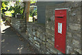
Postbox, Tyne Road, Bishopston
George V postbox BS7 337 is on Tyne Road opposite the junction with Wolseley Road.
Image: © Derek Harper
Taken: 26 Sep 2018
0.01 miles
2
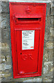
Postbox, Tyne Road, Bishopston
A close look at George V postbox BS7 337, seen in more context at Image
Image: © Derek Harper
Taken: 26 Sep 2018
0.01 miles
3
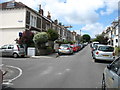
Raglan Road, Bishopston, Bristol
With the entrance to the cul-de-sac Pine Grove Place on the left.
Image: © David Purchase
Taken: 10 Jul 2017
0.04 miles
4
Tyne Road, Bishopston
Approaching the crossroads with Shadwell Road, about 30 metres ahead.
Image: © Derek Harper
Taken: 26 Sep 2018
0.05 miles
5
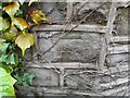
Ordnance Survey Cut Mark
This OS cut mark can be found on the wall south side of Shadwell Road. It marks a point 47.131m above mean sea level.
Image: © Adrian Dust
Taken: 1 Jul 2022
0.05 miles
6
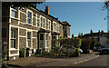
Houses on Tyne Road, Bishopston
At the junction with Claremont Road (right).
Image: © Derek Harper
Taken: 26 Sep 2018
0.06 miles
7
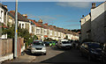
Wolseley Road, Bishopston
The central of three residential streets linking Tyne Road to the Gloucester Road, but the only one with a double bend like this.
Image: © Derek Harper
Taken: 26 Sep 2018
0.06 miles
8
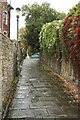
Tyne Path
A reverse view of Image], looking up to the top of footpath BCC 193/10 on a wet day. The path emerges at the junction of Claremont Road with Tyne Road.
Image: © Derek Harper
Taken: 27 Sep 2017
0.06 miles
9
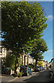
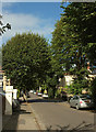
Claremont Road. Bishopston
Trees line the residential road,
Image: © Derek Harper
Taken: 26 Sep 2018
0.06 miles
10
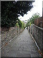
Tyne Path
A small steep passage, a leftover from when this area was Claremont park and not surrounded by houses.
Image: © Neil Owen
Taken: 11 Oct 2022
0.07 miles