IMAGES TAKEN NEAR TO
Elton Road, BRISTOL, BS7 8DD
Introduction
This page details the photographs taken nearby to Elton Road, BS7 8DD by members of the Geograph project.
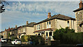
The Geograph project started in 2005 with the aim of publishing, organising and preserving representative images for every square kilometre of Great Britain, Ireland and the Isle of Man.

There are currently over 7.5m images from over14,400 individuals and you can help contribute to the project by visiting https://www.geograph.org.uk
Image Map
Images are licensed for reuse under creativecommons.org/licenses/by-sa/2.0
Notes
- Clicking on the map will re-center to the selected point.
- The higher the marker number, the further away the image location is from the centre of the postcode.
Image Listing (263 Images Found)
Images are licensed for reuse under creativecommons.org/licenses/by-sa/2.0
Image
Details
Distance
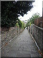
1
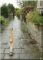
Tyne Path
Looking up footpath BCC 193/10 from its lower end, shown in Image
Image: © Derek Harper
Taken: 27 Sep 2017
0.03 miles
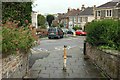
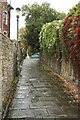
2
Footpath joining Claremont Road and Elton Road
Claremont Road is at the top, and Elton Road at the bottom of the footpath which is called Tyne Path. It is a handy shortcut, and is quite steep.
Image: © Linda Bailey
Taken: 24 Mar 2006
0.03 miles
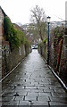
3
Foot of Tyne Path
Footpath BCC 193/10 Image] emerges at its southern end onto Purton Road at its junction with Elton Road.
Image: © Derek Harper
Taken: 27 Sep 2017
0.03 miles
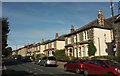
4
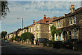
Houses on Cranbrook Road
Taken a little further north along the B4054 from Image
Image: © Derek Harper
Taken: 19 Oct 2022
0.04 miles
5
Houses on Cranbrook Road
This is the B4054.
Image: © Derek Harper
Taken: 19 Oct 2022
0.04 miles
6
Houses on Cranbrook Road
Further northwest from Image The houses beyond the modern detached house are opposite the junction with Carnarvon Road.
Image: © Derek Harper
Taken: 19 Oct 2022
0.04 miles
7
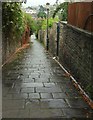
Tyne Path
The path (footpath BCC 193/10) is also shown, in similar weather, in Image
Image: © Derek Harper
Taken: 27 Sep 2017
0.04 miles
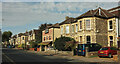
8
Cranbrook Road, Bristol
The B4054, here lined with semi-detached houses.
Image: © Derek Harper
Taken: 28 Oct 2017
0.04 miles
9
Tyne Path
A small steep passage, a leftover from when this area was Claremont park and not surrounded by houses.
Image: © Neil Owen
Taken: 11 Oct 2022
0.05 miles
10
Tyne Path
A reverse view of Image], looking up to the top of footpath BCC 193/10 on a wet day. The path emerges at the junction of Claremont Road with Tyne Road.
Image: © Derek Harper
Taken: 27 Sep 2017
0.05 miles