IMAGES TAKEN NEAR TO
The Wicketts, BRISTOL, BS7 0SR
Introduction
This page details the photographs taken nearby to The Wicketts, BS7 0SR by members of the Geograph project.
The Geograph project started in 2005 with the aim of publishing, organising and preserving representative images for every square kilometre of Great Britain, Ireland and the Isle of Man.

There are currently over 7.5m images from over14,400 individuals and you can help contribute to the project by visiting https://www.geograph.org.uk
Image Map
Images are licensed for reuse under creativecommons.org/licenses/by-sa/2.0
Notes
- Clicking on the map will re-center to the selected point.
- The higher the marker number, the further away the image location is from the centre of the postcode.
Image Listing (38 Images Found)
Images are licensed for reuse under creativecommons.org/licenses/by-sa/2.0
Image
Details
Distance
1
Filton (Bristol) St Theresa of Lisieux Catholic church
Image: © ChurchCrawler
Taken: Unknown
0.06 miles
2
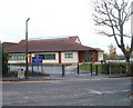
Charborough Road Primary School, Filton
There are about 240 pupils enrolled at the school, located a few metres west of Gloucester Road North (A38).
Image: © Jaggery
Taken: 6 Nov 2010
0.06 miles
3
Corner of The Wickets and Gloucester Road North, Filton
Viewed across Gloucester Road North (A38).
Image: © Jaggery
Taken: 6 Nov 2010
0.06 miles
4
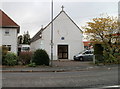
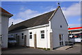
St Teresa's church hall, Filton
This was formerly St Teresa's church. It became the church hall when the current church http://www.geograph.org.uk/photo/2148553 opened in 1961.
Image: © Jaggery
Taken: 6 Nov 2010
0.07 miles
5
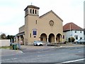
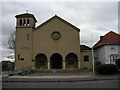
St Teresa's Catholic Church, Filton
Located on Gloucester Road North. The presbytery (priests' house) is on the right.
The full name of the church is St Teresa of the Child Jesus, in the Diocese of Clifton. The church, built in the Roman Basilica style, was completed in 1961. The previous church, http://www.geograph.org.uk/photo/2148565 on the other side of the presbytery, is now used as the church hall.
Image: © Jaggery
Taken: 6 Nov 2010
0.07 miles
6
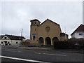
St Teresa of the Child Jesus
Roman Catholic church in Filton, situated alongside the busy A38.
Image: © Eirian Evans
Taken: 29 Jan 2016
0.07 miles
7
St Teresa's Church Hall
There is an OS flush bracket benchmark Image on the left side on the buttress on the near corner buttress
Image: © Roger Templeman
Taken: 2 Mar 2013
0.08 miles
8
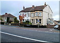
Junction of Gloucester Road North and Broncksea Road
The house on the corner is probably #39 Gloucester Road North, but nothing displayed!
Image: © Roger Templeman
Taken: 2 Mar 2013
0.08 miles
9
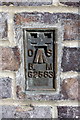
Benchmark on buttress of St Teresa's Church Hall
Ordnance Survey flush bracket (serial number G2583) benchmark described on the Bench Mark Database at http://www.bench-marks.org.uk/bm14565
Image: © Roger Templeman
Taken: 2 Mar 2013
0.08 miles
10
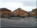
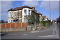
Sinclair House, Filton
Sheltered housing (flats) located at 64 Gloucester Road North.
Image: © Jaggery
Taken: 6 Nov 2010
0.09 miles