IMAGES TAKEN NEAR TO
Kipling Road, BRISTOL, BS7 0QR
Introduction
This page details the photographs taken nearby to Kipling Road, BS7 0QR by members of the Geograph project.
The Geograph project started in 2005 with the aim of publishing, organising and preserving representative images for every square kilometre of Great Britain, Ireland and the Isle of Man.

There are currently over 7.5m images from over14,400 individuals and you can help contribute to the project by visiting https://www.geograph.org.uk
Image Map (Loading...)


Getting Data...Please wait
Leaflet Map data © OpenStreetMap
Images are licensed for reuse under creativecommons.org/licenses/by-sa/2.0
Notes
- Clicking on the map will re-center to the selected point.
- The higher the marker number, the further away the image location is from the centre of the postcode.
Image Listing (91 Images Found)
Images are licensed for reuse under creativecommons.org/licenses/by-sa/2.0
Image
Details
Distance
1
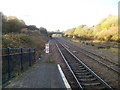
The view SW from Filton Abbey Wood railway station
Looking in the direction of central Bristol, and Temple Meads station.
Image: © Jaggery
Taken: 6 Nov 2010
0.03 miles
2
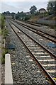
Railway lines towards an overbridge, Filton
Viewed from the SW end of platform 1 https://www.geograph.org.uk/photo/7292585 at Filton Abbey Wood station in South Gloucestershire.
Image: © Jaggery
Taken: 23 Sep 2022
0.04 miles
3
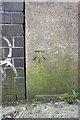
Benchmark on footbridge SW of Filton Abbey Wood station
Ordnance Survey cut mark benchmark described on the Bench Mark Database at http://www.bench-marks.org.uk/bm41602
Image: © Roger Templeman
Taken: 24 Mar 2012
0.04 miles
4
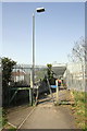
Footbridge leading to Kipling Road
The bridge is southwest of Filton Abbey Wood station and has an OS benchmark Image on the left hand side parapet
Image: © Roger Templeman
Taken: 24 Mar 2012
0.04 miles
5
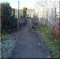
Frosty approach to a railway footbridge, Filton
Concorde Way is behind the camera. The footbridge over railway lines leads to Kipling Road.
Overnight hoar frost remains on the grass and the approach to the bridge has icy patches. The rays of the sun have cleared the wintriness from the opposite side. http://www.geograph.org.uk/photo/3795935
Image: © Jaggery
Taken: 29 Dec 2013
0.04 miles
6
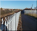
Grey fences alongside Concorde Way, Filton
The fence on the left, with curved spikes, is at the perimeter of a railway.
The fence on the right encloses an electricity substation.
Image: © Jaggery
Taken: 29 Dec 2013
0.05 miles
7
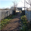
Sunny side of a railway footbridge near Filton Abbey Wood railway station
The footbridge leads to Concorde Way, a footpath and cycleway. The rays of the sun have melted overnight hoar frost and icy patches on this side, but not yet on the opposite side. http://www.geograph.org.uk/photo/3795915
Image: © Jaggery
Taken: 29 Dec 2013
0.05 miles
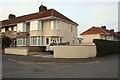
8
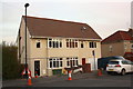
New houses on Wallscourt Road South
Image: © Roger Templeman
Taken: 12 Mar 2016
0.05 miles
9
Junction of Ninth Avenue and Kipling Road
Image: © Roger Templeman
Taken: 12 Mar 2016
0.06 miles
10
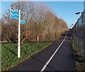
Concorde Way signpost, Filton
The footpath and cycleway here skirt the perimeter fence of a Ministry of Defence site. The arm pointing ahead shows the precise distance of 525 yards to Filton Abbey Wood (railway station). The nearest location shown on a left-pointing arm is Lockleaze (1 mile). The side path leads to a footbridge over railway lines.
Image: © Jaggery
Taken: 29 Dec 2013
0.07 miles