IMAGES TAKEN NEAR TO
Filton Road, BRISTOL, BS7 0PB
Introduction
This page details the photographs taken nearby to Filton Road, BS7 0PB by members of the Geograph project.
The Geograph project started in 2005 with the aim of publishing, organising and preserving representative images for every square kilometre of Great Britain, Ireland and the Isle of Man.

There are currently over 7.5m images from over14,400 individuals and you can help contribute to the project by visiting https://www.geograph.org.uk
Image Map
Images are licensed for reuse under creativecommons.org/licenses/by-sa/2.0
Notes
- Clicking on the map will re-center to the selected point.
- The higher the marker number, the further away the image location is from the centre of the postcode.
Image Listing (55 Images Found)
Images are licensed for reuse under creativecommons.org/licenses/by-sa/2.0
Image
Details
Distance
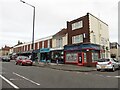
2
Co-operative Store, Horfield
On the A38 between Beverley Road and Boston Road.
Image: © Eirian Evans
Taken: 26 Sep 2010
0.02 miles
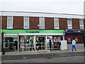
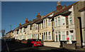
3
Boston Road, Horfield
At the corner with the A38 Filton Road.
Image: © Derek Harper
Taken: 7 Feb 2018
0.03 miles
4
Toronto Road, Horfield
At the traffic lights where the road meets the A38 Filton Road, with a starkly shadowed pollarded tree.
Image: © Derek Harper
Taken: 7 Feb 2018
0.04 miles
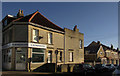
5
Boston Road, Horfield
From the Filton Road end.
Image: © Derek Harper
Taken: 7 Feb 2018
0.04 miles
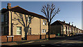
6
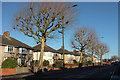
A38 Filton Road
Pollarded trees line the main road; this stretch is between Doone Road and Boston Road.
Image: © Derek Harper
Taken: 7 Feb 2018
0.05 miles
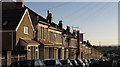
7
Toronto Road, Horfield
A last terrace, of nine, before the junction with the A38 Filton Road; also seen on the right of Image
Image: © Derek Harper
Taken: 7 Feb 2018
0.05 miles
8
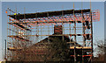
House under scaffolding, Horfield
A house on Monks Park Avenue near the Filton Road crossroads.
Image: © Derek Harper
Taken: 7 Feb 2018
0.07 miles
9
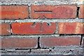
Benchmark on wall fronting #30 Toronto Road
Ordnance Survey cut mark benchmark described on the Bench Mark Database at http://www.bench-marks.org.uk/bm47499
Image: © Roger Templeman
Taken: 2 Mar 2013
0.08 miles
10
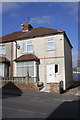
#30 Toronto Road
There is an OS benchmark Image on the house's fronting wall (in the part in shadow)
Image: © Roger Templeman
Taken: 2 Mar 2013
0.08 miles