IMAGES TAKEN NEAR TO
Montreal Avenue, BRISTOL, BS7 0NJ
Introduction
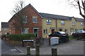
This page details the photographs taken nearby to Montreal Avenue, BS7 0NJ by members of the Geograph project.
The Geograph project started in 2005 with the aim of publishing, organising and preserving representative images for every square kilometre of Great Britain, Ireland and the Isle of Man.

There are currently over 7.5m images from over14,400 individuals and you can help contribute to the project by visiting https://www.geograph.org.uk
Image Map
Images are licensed for reuse under creativecommons.org/licenses/by-sa/2.0
Notes
- Clicking on the map will re-center to the selected point.
- The higher the marker number, the further away the image location is from the centre of the postcode.
Image Listing (66 Images Found)
Images are licensed for reuse under creativecommons.org/licenses/by-sa/2.0
Image
Details
Distance
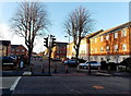
1
Hughes Gardens, Horfield, Bristol
Viewed across Filton Avenue. A sign on the left shows a 20 (mph speed limit) whereas the one on the right shows 30. It looks like the sign on the left has been reversed.
Image: © Jaggery
Taken: 29 Dec 2013
0.04 miles
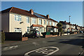
2
Hughes Gardens, Bristol
Seen across Filton Avenue.
Image: © Derek Harper
Taken: 7 Feb 2018
0.05 miles
3
Joyce Close, Horfield, Bristol
Joyce Close is a short cul-de-sac on the west side of Filton Avenue.
Image: © Jaggery
Taken: 29 Dec 2013
0.06 miles
4
Shakespeare Avenue, Horfield, Bristol
Shakespeare Avenue behind the camera continues ahead, on the west side of Filton Avenue.
Image: © Jaggery
Taken: 29 Dec 2013
0.07 miles
5
2011 : Shakespeare Avenue, Northville looking west
A recent development, though the london plane trees are at least 100 years old.
Planted around 1900 for their ability to thrive in almost any conditions, at that time they needed to be muck resistant even this far from the centre of Bristol.
Image: © Maurice Pullin
Taken: 2 May 2011
0.07 miles
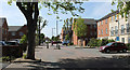
6
2011 : Filton Avenue, Northville, Bristol looking south
Near Shakespeare Avenue.
Image: © Maurice Pullin
Taken: 2 May 2011
0.08 miles
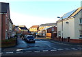
7
Toronto Road, Horfield
From close to the crossroads with Filton Avenue.
Image: © Derek Harper
Taken: 7 Feb 2018
0.08 miles
8
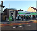
Electricity substation and a Co-operative Food store in Horfield, Bristol
Viewed across Filton Avenue.
Image: © Jaggery
Taken: 29 Dec 2013
0.08 miles
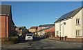
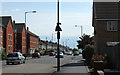
9
Toronto Road, Horfield
Taken on the stretch between the junctions with Hazel Grove and Keys Avenue.
Image: © Derek Harper
Taken: 7 Feb 2018
0.09 miles