IMAGES TAKEN NEAR TO
Hazel Grove, BRISTOL, BS7 0NG
Introduction
This page details the photographs taken nearby to Hazel Grove, BS7 0NG by members of the Geograph project.
The Geograph project started in 2005 with the aim of publishing, organising and preserving representative images for every square kilometre of Great Britain, Ireland and the Isle of Man.

There are currently over 7.5m images from over14,400 individuals and you can help contribute to the project by visiting https://www.geograph.org.uk
Image Map (Loading...)


Getting Data...Please wait
Leaflet Map data © OpenStreetMap
Images are licensed for reuse under creativecommons.org/licenses/by-sa/2.0
Notes
- Clicking on the map will re-center to the selected point.
- The higher the marker number, the further away the image location is from the centre of the postcode.
Image Listing (69 Images Found)
Images are licensed for reuse under creativecommons.org/licenses/by-sa/2.0
Image
Details
Distance
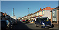
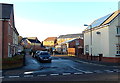
1
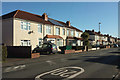
Toronto Road, Horfield
Taken on the stretch between the junctions with Hazel Grove and Keys Avenue.
Image: © Derek Harper
Taken: 7 Feb 2018
0.09 miles
2
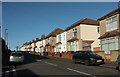
Toronto Road, Horfield
In the foreground is the junction with Manx Road.
Image: © Derek Harper
Taken: 7 Feb 2018
0.11 miles
3
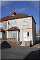
#30 Toronto Road
There is an OS benchmark Image on the house's fronting wall (in the part in shadow)
Image: © Roger Templeman
Taken: 2 Mar 2013
0.11 miles
4
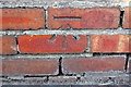
Benchmark on wall fronting #30 Toronto Road
Ordnance Survey cut mark benchmark described on the Bench Mark Database at http://www.bench-marks.org.uk/bm47499
Image: © Roger Templeman
Taken: 2 Mar 2013
0.11 miles
5
Toronto Road, Horfield
From close to the crossroads with Filton Avenue.
Image: © Derek Harper
Taken: 7 Feb 2018
0.12 miles
6
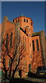
St Gregory The Great Church, Bristol
Another view of the octagonal tower shown in Image
Image: © Derek Harper
Taken: 7 Feb 2018
0.12 miles
7
St Gregory The Great Church, Bristol
The whole church is shown at Image "1936 by A.R.Gough" http://www.churchcrawler.co.uk/pmdraper10/bristol1.htm .
Image: © Derek Harper
Taken: 7 Feb 2018
0.12 miles
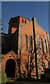
8
St Gregory The Great Church, Bristol
A view from the northeast of Image
Image: © Derek Harper
Taken: 7 Feb 2018
0.12 miles
9
Hughes Gardens, Horfield, Bristol
Viewed across Filton Avenue. A sign on the left shows a 20 (mph speed limit) whereas the one on the right shows 30. It looks like the sign on the left has been reversed.
Image: © Jaggery
Taken: 29 Dec 2013
0.12 miles
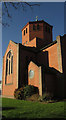
10
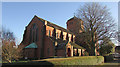
St Gregory The Great Church, Bristol
A similar view to Image, taken a little close to. That yew seems to have hone over the intervening years.
Image: © Derek Harper
Taken: 7 Feb 2018
0.12 miles