IMAGES TAKEN NEAR TO
Holton Road, BRISTOL, BS7 0EP
Introduction
This page details the photographs taken nearby to Holton Road, BS7 0EP by members of the Geograph project.
The Geograph project started in 2005 with the aim of publishing, organising and preserving representative images for every square kilometre of Great Britain, Ireland and the Isle of Man.

There are currently over 7.5m images from over14,400 individuals and you can help contribute to the project by visiting https://www.geograph.org.uk
Image Map
Images are licensed for reuse under creativecommons.org/licenses/by-sa/2.0
Notes
- Clicking on the map will re-center to the selected point.
- The higher the marker number, the further away the image location is from the centre of the postcode.
Image Listing (25 Images Found)
Images are licensed for reuse under creativecommons.org/licenses/by-sa/2.0
Image
Details
Distance
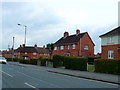
1
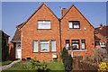
Two semis with different road addresses
The right hand house is #111 Wordsworth Road: the left hand house is #27 Holton Road and has an OS benchmark Image to the left of its front door
Image: © Roger Templeman
Taken: 24 Mar 2012
0.03 miles
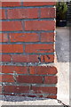
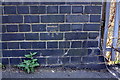
2
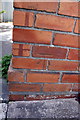
Benchmark on #27 Holton Road
Ordnance Survey cut mark benchmark described on the Bench Mark Database at http://www.bench-marks.org.uk/bm42173
Image: © Roger Templeman
Taken: 24 Mar 2012
0.03 miles
3
Blakeney Road, Horfield
Round the corner shown in Image], with short terraces taking over from semis.
Image: © Derek Harper
Taken: 29 Sep 2014
0.04 miles
4
Blakeney Road, Horfield
Semis round a corner on this residential road.
Image: © Derek Harper
Taken: 29 Sep 2014
0.06 miles
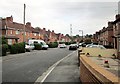
5
Houses on Lockleaze Rd
This type of red brick social housing is quite extensive in the north of Bristol. These terraced houses are at the junction with Blakeney Rd in Horfield.
Image: © Nigel Mykura
Taken: 23 Feb 2013
0.10 miles
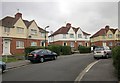
6
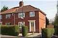
Semi-detached houses on Wordsworth Road
There is an OS benchmark Image on the front right corner of the near house
Image: © Roger Templeman
Taken: 24 Mar 2012
0.12 miles
7
Benchmark on #102 Wordsworth Road
Ordnance Survey cut mark benchmark described on the Bench Mark Database at http://www.bench-marks.org.uk/bm42156
Image: © Roger Templeman
Taken: 24 Mar 2012
0.12 miles
8
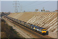
Filton Bank
Bristol - Cardiff railway line in the deep cutting at Horfield, near Filton.
Image: © Wayland Smith
Taken: 19 Mar 2009
0.12 miles
9
Benchmark on railway Bridge 03m29c, Constable Road
Ordnance Survey cut mark benchmark described on the Bench Mark Database at http://www.bench-marks.org.uk/bm42174
Image: © Roger Templeman
Taken: 24 Mar 2012
0.13 miles
10
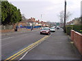
Lockleaze Road
Looking east along Lockleaze Road past the blue railings of Filton Avenue Infant School.
Image: © Linda Bailey
Taken: 5 Jan 2006
0.14 miles