IMAGES TAKEN NEAR TO
Court Road, BRISTOL, BS7 0BU
Introduction
This page details the photographs taken nearby to Court Road, BS7 0BU by members of the Geograph project.
The Geograph project started in 2005 with the aim of publishing, organising and preserving representative images for every square kilometre of Great Britain, Ireland and the Isle of Man.

There are currently over 7.5m images from over14,400 individuals and you can help contribute to the project by visiting https://www.geograph.org.uk
Image Map
Images are licensed for reuse under creativecommons.org/licenses/by-sa/2.0
Notes
- Clicking on the map will re-center to the selected point.
- The higher the marker number, the further away the image location is from the centre of the postcode.
Image Listing (75 Images Found)
Images are licensed for reuse under creativecommons.org/licenses/by-sa/2.0
Image
Details
Distance
1
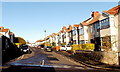
Darnley Avenue, Horfield, Bristol
Viewed across Muller Road looking towards Court Road.
Image: © Jaggery
Taken: 29 Dec 2013
0.01 miles
2
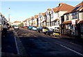
Parkstone Avenue, Horfield, Bristol
Viewed from the Muller Road end looking towards Court Road.
Image: © Jaggery
Taken: 29 Dec 2013
0.04 miles
3
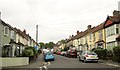
Highbury Road, Horfield
Looking up the road that Image looks down, from the junction with Darnley Avenue.
Image: © Derek Harper
Taken: 29 Sep 2014
0.04 miles
4
Wessex Avenue, Horfield
Looking east down Wessex Avenue towards Purdown and the Purdown Communication Tower on the horizon.
Image: © Linda Bailey
Taken: 5 Jan 2006
0.05 miles
5
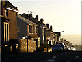
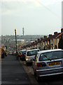
Looking down Highbury Road
Looking down Highbury Road in the early morning light shows how the land falls away here.
Image: © Linda Bailey
Taken: 3 Feb 2007
0.07 miles
6

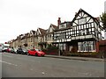
Half timbered house on the Gloucester Road (A38)
The half timbered house on the Gloucester Road (A38) opposite the junction with Kellaway Avenue.
Image: © Linda Bailey
Taken: 15 Mar 2006
0.07 miles
8
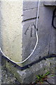
Benchmark on #573 Gloucester Road
Ordnance Survey cut mark benchmark described on the Bench Mark Database at http://www.bench-marks.org.uk/bm47500
Image: © Roger Templeman
Taken: 2 Mar 2013
0.08 miles
9
Ordnance Survey Cut Mark
This OS cut mark can be found on No573 Gloucester Road. It marks a point 82.537m above mean sea level.
Image: © Adrian Dust
Taken: 1 Jul 2022
0.08 miles
10
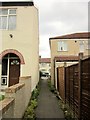
Alley, Horfield Common
Linking Bayswater Road to Wessex Avenue. This is footpath BCC/550.
Image: © Derek Harper
Taken: 29 Sep 2014
0.08 miles