IMAGES TAKEN NEAR TO
Filton Avenue, BRISTOL, BS7 0BB
Introduction
This page details the photographs taken nearby to Filton Avenue, BS7 0BB by members of the Geograph project.
The Geograph project started in 2005 with the aim of publishing, organising and preserving representative images for every square kilometre of Great Britain, Ireland and the Isle of Man.

There are currently over 7.5m images from over14,400 individuals and you can help contribute to the project by visiting https://www.geograph.org.uk
Image Map
Images are licensed for reuse under creativecommons.org/licenses/by-sa/2.0
Notes
- Clicking on the map will re-center to the selected point.
- The higher the marker number, the further away the image location is from the centre of the postcode.
Image Listing (33 Images Found)
Images are licensed for reuse under creativecommons.org/licenses/by-sa/2.0
Image
Details
Distance
2
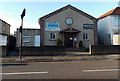
Ebenezer Church, Horfield, Bristol
Ebenezer Church (also known as Ebe) is an independent evangelical church at 286 Filton Avenue.
Image: © Jaggery
Taken: 29 Dec 2013
0.02 miles
3
Horfield & Lockleaze Library, Filton Avenue
There is an OS benchmark Image on the near corner of the building, left hand face, right of the metal gate
Image: © Roger Templeman
Taken: 12 Mar 2016
0.07 miles
4
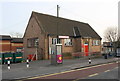
Horfield & Lockleaze Library, Bristol
Viewed across Filton Avenue, the public library is part of the Bristol City Council library service.
Image: © Jaggery
Taken: 29 Dec 2013
0.07 miles
5
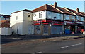
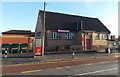
The Candy Shop, Horfield, Bristol
Convenience store at 368 Filton Avenue, on the corner of Reynold's Walk.
Image: © Jaggery
Taken: 29 Dec 2013
0.07 miles
6
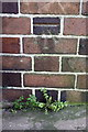
Benchmark on library, Filton Avenue
Ordnance Survey cut mark benchmark described on the Bench Mark Database at http://www.bench-marks.org.uk/bm74141
Image: © Roger Templeman
Taken: 12 Mar 2016
0.07 miles
7
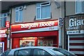
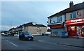
Bargain Booze Plus on Filton Road, Horfield
There are quite a few of these in Bristol, they are clearly popular.
Image: © David Howard
Taken: 1 Jun 2019
0.08 miles
8
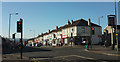
Traffic lights on Filton Avenue
The crossroads with Toronto Road / Bridge Walk.
Image: © Derek Harper
Taken: 7 Feb 2018
0.10 miles
9
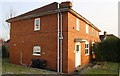
#2 Dorchester Road and #1 Camborne Road
There is an OS benchmark Image on the near corner, left hand face, of the semi-detached pair
Image: © Roger Templeman
Taken: 12 Mar 2016
0.11 miles
10
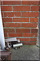
Benchmark on #2 Dorchester Road
Ordnance Survey cut mark benchmark described on the Bench Mark Database at http://www.bench-marks.org.uk/bm74140
Image: © Roger Templeman
Taken: 12 Mar 2016
0.11 miles