IMAGES TAKEN NEAR TO
Golden Hill, BRISTOL, BS6 7YG
Introduction
This page details the photographs taken nearby to Golden Hill, BS6 7YG by members of the Geograph project.
The Geograph project started in 2005 with the aim of publishing, organising and preserving representative images for every square kilometre of Great Britain, Ireland and the Isle of Man.

There are currently over 7.5m images from over14,400 individuals and you can help contribute to the project by visiting https://www.geograph.org.uk
Image Map
Images are licensed for reuse under creativecommons.org/licenses/by-sa/2.0
Notes
- Clicking on the map will re-center to the selected point.
- The higher the marker number, the further away the image location is from the centre of the postcode.
Image Listing (56 Images Found)
Images are licensed for reuse under creativecommons.org/licenses/by-sa/2.0
Image
Details
Distance
1
Ordnance Survey Cut Mark
This OS cut mark can be found on No105 Kellaway Avenue. It marks a point 83.323m above mean sea level.
Image: © Adrian Dust
Taken: 1 Jul 2022
0.01 miles
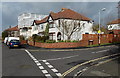
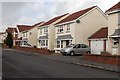
2
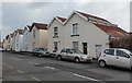
Kellaway Avenue houses, Bristol
Viewed across the B4468 Kellaway Avenue between the Phoenix Grove junction and the Brookland Road junction.
Image: © Jaggery
Taken: 30 Jan 2013
0.03 miles
4
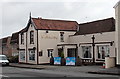
The Kellaway pub, Bristol
Located at 138-140 Kellaway Avenue in the Golden Hill area of Bristol.
Image: © Jaggery
Taken: 30 Jan 2013
0.04 miles
5
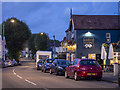
Kellaway Avenue, Bristol
Kellaway Avenue in Bristol. The pub on the right is the Gloucester Old Spot.
Image: © Rossographer
Taken: 7 Aug 2019
0.05 miles
6
Corner of Stadium Road and Phoenix Grove, Bristol
Stadium Road is on the right.
Image: © Jaggery
Taken: 30 Jan 2013
0.06 miles
7
SE end of Phoenix Grove, Bristol
Viewed across Kellaway Avenue.
Image: © Jaggery
Taken: 30 Jan 2013
0.06 miles
8
Phoenix Grove, Bristol
Viewed from the edge of a footpath http://www.geograph.org.uk/photo/3330924 from Henleaze Park,
looking past the left turn for Wimbledon Road http://www.geograph.org.uk/photo/3330918 towards Kellaway Avenue.
Image: © Jaggery
Taken: 30 Jan 2013
0.06 miles
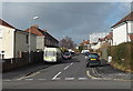
9
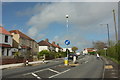
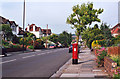
Pedestrian refuge, Kellaway Avenue, Bristol
Not required by that pedestrian, anyway. This is the B4468.
Image: © Derek Harper
Taken: 2 May 2016
0.08 miles
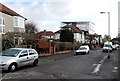
10
Brookland Road, Bristol
Viewed from the Kellaway Avenue end.
Image: © Jaggery
Taken: 30 Jan 2013
0.08 miles