IMAGES TAKEN NEAR TO
Howard Road, BRISTOL, BS6 7UT
Introduction
This page details the photographs taken nearby to Howard Road, BS6 7UT by members of the Geograph project.
The Geograph project started in 2005 with the aim of publishing, organising and preserving representative images for every square kilometre of Great Britain, Ireland and the Isle of Man.

There are currently over 7.5m images from over14,400 individuals and you can help contribute to the project by visiting https://www.geograph.org.uk
Image Map
Images are licensed for reuse under creativecommons.org/licenses/by-sa/2.0
Notes
- Clicking on the map will re-center to the selected point.
- The higher the marker number, the further away the image location is from the centre of the postcode.
Image Listing (109 Images Found)
Images are licensed for reuse under creativecommons.org/licenses/by-sa/2.0
Image
Details
Distance
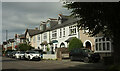
1
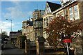
Howard Road, Westbury Park
With a couple of flat-roofed bays, one undergoing repair.
Image: © Derek Harper
Taken: 25 Oct 2017
0.03 miles
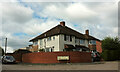
2
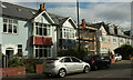
Houses on Linden Road, Bristol
Construction work takes place on an end-of-terrace on the north-east side of the B4054.
Image: © Derek Harper
Taken: 6 Oct 2023
0.04 miles
3
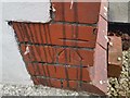
Ordnance Survey Cut Mark
This OS cut mark can be found on No69 Linden Road. It marks a point 78.986m above mean sea level.
Image: © Adrian Dust
Taken: 17 Jan 2020
0.04 miles
4
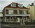
House on Howard Road, Bristol
Seen across the junction with Linden Road.
Image: © Derek Harper
Taken: 6 Oct 2023
0.04 miles
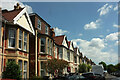
5
Linden Road, Bristol
Terraced houses on the B4054 in Westbury Park.
Image: © Derek Harper
Taken: 6 Oct 2023
0.05 miles
6
Houses, Westbury Park
Semis at the corner of White Tree Road and Brean Down Avenue (right).
Image: © Derek Harper
Taken: 10 Sep 2022
0.07 miles
7
St Alban's Road, Westbury Park
Emerging from a left bend.
Image: © Derek Harper
Taken: 17 Jul 2021
0.07 miles
8
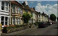
St Alban's Road, Westbury Park
One of numerous streets of Victorian terraces in the area.
Image: © Derek Harper
Taken: 17 Jul 2021
0.08 miles
9
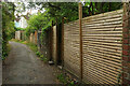
Back Lane, Westbury Park
Between St Alban's Road and Devonshire Road.
Image: © Derek Harper
Taken: 10 Sep 2021
0.09 miles
10

Potato vine, Westbury Park
On the back lane between Devonshire Road and St Alban's Road.
Image: © Derek Harper
Taken: 11 Sep 2021
0.09 miles