IMAGES TAKEN NEAR TO
Linden Road, BRISTOL, BS6 7RL
Introduction
This page details the photographs taken nearby to Linden Road, BS6 7RL by members of the Geograph project.
The Geograph project started in 2005 with the aim of publishing, organising and preserving representative images for every square kilometre of Great Britain, Ireland and the Isle of Man.

There are currently over 7.5m images from over14,400 individuals and you can help contribute to the project by visiting https://www.geograph.org.uk
Image Map
Images are licensed for reuse under creativecommons.org/licenses/by-sa/2.0
Notes
- Clicking on the map will re-center to the selected point.
- The higher the marker number, the further away the image location is from the centre of the postcode.
Image Listing (114 Images Found)
Images are licensed for reuse under creativecommons.org/licenses/by-sa/2.0
Image
Details
Distance
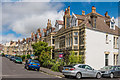
1
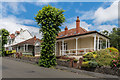
2 and 4 Linden Road
Pair of distinctive bungalows with verandahs, situated at the fork of Linden Road and Upper Cranbrook Road.
Image: © Ian Capper
Taken: 25 Jun 2017
0.04 miles
2
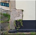
Ordnance Survey Cut Mark
This OS cut mark can be found on No32 Linden Road. It marks a point 78.132m above mean sea level.
Image: © Adrian Dust
Taken: 17 Jan 2020
0.05 miles
3
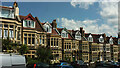
Terrace on Harcourt Road, Westbury Park
Looking right from Image
Image: © Derek Harper
Taken: 17 Jul 2021
0.06 miles
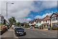
4
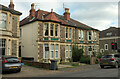
Semi on Linden Road
The semi in the centre just falls within the centisquare. On the right are traffic lights at the B4054's crossroads with Coldharbour Road.
Image: © Derek Harper
Taken: 6 Oct 2023
0.06 miles
5
Upper Cranbrook Road
Upper Cranbrook Road is shown undeveloped on the 1903 6 inch map, but building doesn't appear to have taken place before the 1930s.
Image: © Ian Capper
Taken: 25 Jun 2017
0.06 miles
6
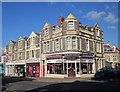
Shops on Coldharbour Road
Part of a small shopping area that might be in Westbury Park, or is it Redland?
Image: © Derek Harper
Taken: 10 Jun 2015
0.07 miles
7

Building, Westbury Park
The Split Tin bakery occupies the corner site at the junction of Coldharbour Road and Harcourt Road.
Image: © Derek Harper
Taken: 17 Jul 2021
0.07 miles
9
Harcourt Road
Early 20th Century villas in Westbury Park, with this area being called New Clifton in maps of the time.
Image: © Ian Capper
Taken: 25 Jun 2017
0.07 miles
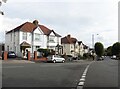
10

St Alban's Road, Bristol
Terraced houses leading down to a junction with Coldharbour Road.
Image: © Derek Harper
Taken: 29 Dec 2017
0.07 miles