IMAGES TAKEN NEAR TO
Downs Park West, BRISTOL, BS6 7QH
Introduction
This page details the photographs taken nearby to Downs Park West, BS6 7QH by members of the Geograph project.
The Geograph project started in 2005 with the aim of publishing, organising and preserving representative images for every square kilometre of Great Britain, Ireland and the Isle of Man.

There are currently over 7.5m images from over14,400 individuals and you can help contribute to the project by visiting https://www.geograph.org.uk
Image Map
Images are licensed for reuse under creativecommons.org/licenses/by-sa/2.0
Notes
- Clicking on the map will re-center to the selected point.
- The higher the marker number, the further away the image location is from the centre of the postcode.
Image Listing (99 Images Found)
Images are licensed for reuse under creativecommons.org/licenses/by-sa/2.0
Image
Details
Distance
1
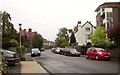
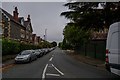
Downs Park West, Westbury Park
It's started to rain quite steadily, hence the deep gloom. On the right is Winford Court, a block of 9 flats.
Image: © Derek Harper
Taken: 29 May 2013
0.02 miles
2
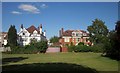
Houses on Downs Park West
Looking to the left across Durdham Down from the same spot as Image
Image: © Derek Harper
Taken: 25 Jun 2015
0.02 miles
4
Old Milestone by Westbury Road, Bristol
Carved stone post by the UC road, in parish of BRISTOL (CITY OF BRISTOL District), Westbury Road, South of Henleaze Road, on Common, on open grass area, on East side of road. Erected by the Bristol Turnpike Trust in the 19th century.
Inscription once read:-
(To)
(the Standard)
(at the top)
(of Park Street)
(2)
Carved benchmark on lower face.
Milestone Society National ID: GL_BRPG02.
Image: © Milestone Society
Taken: 16 Mar 2017
0.04 miles
5
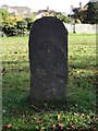
Old Milestone by Westbury Road, Bristol
Carved stone post by the UC road, in parish of BRISTOL (CITY OF BRISTOL District), Westbury Road, South of Henleaze Road, on Common, on open grass area, on East side of road. Erected by the Bristol Turnpike Trust in the 19th century.
Inscription once read:-
(To)
(the Standard)
(at the top)
(of Park Street)
(2)
Carved benchmark on lower face.
Milestone Society National ID: GL_BRPG02.
Image: © Roadside Relics
Taken: 15 Nov 2023
0.04 miles
6

Old Milestone by the A4018, Westbury Road, Bristol
Carved stone post by the A4108, in parish of BRISTOL (CITY OF BRISTOL District), Westbury Road, South of Henleaze Road, on Common, on open grass area, on East side of road. Erected by the Bristol Turnpike Trust in the 19th century.
Inscription once read:-
(To)
(the Standard)
(at the top)
(of Park Street)
(2)
Carved benchmark on lower face.
Milestone Society National ID: GL_BRPL02
Image: © M Faherty
Taken: 7 Mar 2015
0.04 miles
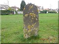
7
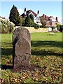
Milestone on Durdham Downs
The face of this milestone is heavily weathered, the only word I could make out was "Park".
Image: © Linda Bailey
Taken: 2 Oct 2006
0.04 miles
8
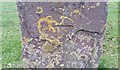
Ordnance Survey Cut Mark
This OS cut mark can be found on the milestone, Westbury Road. It marks a point 80.095m above mean sea level.
Image: © Adrian Dust
Taken: 17 Jan 2020
0.04 miles
9
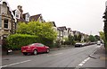
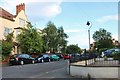
Henleaze Road, Bristol
Semis. The B4058. From the junction with Downs Park West (right). It's raining.
Image: © Derek Harper
Taken: 29 May 2013
0.04 miles
10
Redland : Henleaze Road B4056
Looking off Westbury Road along Henleaze Road.
Image: © Lewis Clarke
Taken: 8 Sep 2020
0.06 miles