IMAGES TAKEN NEAR TO
North View, BRISTOL, BS6 7PY
Introduction
This page details the photographs taken nearby to North View, BS6 7PY by members of the Geograph project.
The Geograph project started in 2005 with the aim of publishing, organising and preserving representative images for every square kilometre of Great Britain, Ireland and the Isle of Man.

There are currently over 7.5m images from over14,400 individuals and you can help contribute to the project by visiting https://www.geograph.org.uk
Image Map
Images are licensed for reuse under creativecommons.org/licenses/by-sa/2.0
Notes
- Clicking on the map will re-center to the selected point.
- The higher the marker number, the further away the image location is from the centre of the postcode.
Image Listing (121 Images Found)
Images are licensed for reuse under creativecommons.org/licenses/by-sa/2.0
Image
Details
Distance
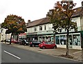
2
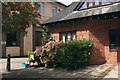
Christian Science Reading Room and church, Bristol
The second church of Christ Scientist is just beyond the reading room, both on North View, Westbury Park. North View is the B4054.
Image: © Derek Harper
Taken: 25 Feb 2017
0.01 miles
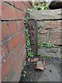
3
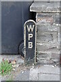
Old Boundary Marker on the B4054 Northview in Bristol
Municipal Boundary Marker on the south side of the B4054 Northview, between No.36 and No.38. On the former boundary of City of Bristol and Westbury upon Trym parish, but now entirely in Bristol.
Milestone Society National ID: GL_BSWEST07pb
Image: © Roadside Relics
Taken: 15 Sep 2022
0.02 miles
5
Church and free apples, Westbury Park
By the Second Church of Christ Scientist are boxes of eating apples and cookers - Bramleys.
Image: © Derek Harper
Taken: 12 Sep 2019
0.02 miles
6
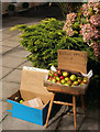
Free apples, Westbury Park
A closer examination of the apples being given away in Image Those do look quite like Coxes, and I'm also fond of Bramleys, but having spent the previous couple of days dealing with our own apples, we passed. Had we know how much crumble our grandsons were about to consume, we would have taken some.
Image: © Derek Harper
Taken: 12 Sep 2019
0.02 miles
7
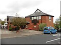
Christian Science Church, Westbury Park
Image: © Roger Cornfoot
Taken: 7 Oct 2020
0.02 miles
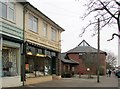
8
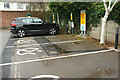
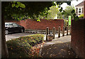
Vehicle charging points, Waitrose
A number of spaces in the Westbury Park store's car park have been made charging points for electric vehicles.
Image: © Derek Harper
Taken: 5 Nov 2022
0.02 miles
9
Path from car park, Westbury Park
Leading from the Waitrose car park onto North View.
Image: © Derek Harper
Taken: 12 Sep 2019
0.03 miles
10
Old Boundary Marker on Berkeley Road. Bristol
Municipal Boundary Marker against the front garden wall between numbers 41 and 43 Berkeley Road. Westbury Park, Bristol. On the former boundary of City of Bristol and Westbury upon Trym parish, but now entirely in Bristol.
Milestone Society National ID: GL_BSWEST06pb.
Image: © Roadside Relics
Taken: 10 Feb 2022
0.05 miles