IMAGES TAKEN NEAR TO
Devonshire Road, BRISTOL, BS6 7NL
Introduction
This page details the photographs taken nearby to Devonshire Road, BS6 7NL by members of the Geograph project.
The Geograph project started in 2005 with the aim of publishing, organising and preserving representative images for every square kilometre of Great Britain, Ireland and the Isle of Man.

There are currently over 7.5m images from over14,400 individuals and you can help contribute to the project by visiting https://www.geograph.org.uk
Image Map
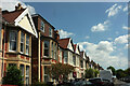
Images are licensed for reuse under creativecommons.org/licenses/by-sa/2.0
Notes
- Clicking on the map will re-center to the selected point.
- The higher the marker number, the further away the image location is from the centre of the postcode.
Image Listing (150 Images Found)
Images are licensed for reuse under creativecommons.org/licenses/by-sa/2.0
Image
Details
Distance
1
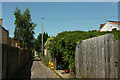
Florence Lane, Westbury Park
Around the curve shown in Image], with a glimpse of houses on Devonshire Road.
Image: © Derek Harper
Taken: 17 Jul 2021
0.02 miles
2
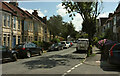
Devonshire Road, Westbury Park
At the junction with Ladysmith Road (right).
Image: © Derek Harper
Taken: 17 Jul 2021
0.03 miles
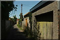
3
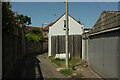
Florence Lane, Westbury Park
Approaching the northwestern end of the back lane shown in Image] and Image] as it turns a corner to meet Ladysmith Road.
Image: © Derek Harper
Taken: 17 Jul 2021
0.03 miles
4
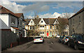
Devonshire Road, Westbury Park
Seen from Ladysmith Road.
Image: © Derek Harper
Taken: 28 Mar 2018
0.04 miles
5
Florence Lane, Westbury Park
The back lane shown in Image] gradually curves to reflect the angle of the roads on either side.
Image: © Derek Harper
Taken: 17 Jul 2021
0.04 miles
6
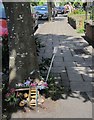
Montage by tree, Devonshire Road
Presumably a rather charming effort to discourage dog mess.
Image: © Derek Harper
Taken: 18 Jul 2015
0.05 miles
7
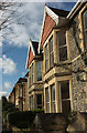
Houses on Florence Park, Westbury Park
With some decorative features.
Image: © Derek Harper
Taken: 28 Mar 2018
0.05 miles
8
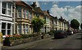
St Alban's Road, Westbury Park
One of numerous streets of Victorian terraces in the area.
Image: © Derek Harper
Taken: 17 Jul 2021
0.06 miles
9
St Alban's Road, Westbury Park
Emerging from a left bend.
Image: © Derek Harper
Taken: 17 Jul 2021
0.06 miles
10

St Helena Road, Westbury Park
Seen from Ladysmith Road. St Helena Road forms a cul-de-sac to the right.
Image: © Derek Harper
Taken: 23 Jun 2015
0.06 miles