IMAGES TAKEN NEAR TO
Coldharbour Road, BRISTOL, BS6 7LZ
Introduction
This page details the photographs taken nearby to Coldharbour Road, BS6 7LZ by members of the Geograph project.
The Geograph project started in 2005 with the aim of publishing, organising and preserving representative images for every square kilometre of Great Britain, Ireland and the Isle of Man.

There are currently over 7.5m images from over14,400 individuals and you can help contribute to the project by visiting https://www.geograph.org.uk
Image Map
Images are licensed for reuse under creativecommons.org/licenses/by-sa/2.0
Notes
- Clicking on the map will re-center to the selected point.
- The higher the marker number, the further away the image location is from the centre of the postcode.
Image Listing (203 Images Found)
Images are licensed for reuse under creativecommons.org/licenses/by-sa/2.0
Image
Details
Distance
1
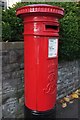
Postbox, Cossins Road
George VI postbox (what I would call a pillar box) BS6 309 is a few metres along Cossins Road from its junction with Coldharbour Road.
Image: © Derek Harper
Taken: 26 Oct 2015
0.02 miles
2
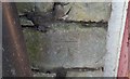
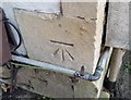
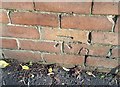
Ordnance Survey Cut Mark
This OS cut mark can be found on the wall NW side of Coldharbour Road. It marks a point 91.940m above mean sea level.
Image: © Adrian Dust
Taken: 20 Jan 2020
0.02 miles
3
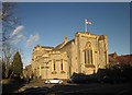
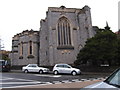
St Alban's church, Redland
Also shown in Image and Image "The high chancel with side aisles and chapels make this '...one of the most thrilling of late Victorian interiors' (Gomme) http://list.english-heritage.org.uk/resultsingle.aspx?uid=1280268&searchtype=mapsearch . Behind on the right is St Alban's Hall. The junction in the foreground is of Blenheim Road (left) with Coldharbour Road.
Image: © Derek Harper
Taken: 27 Dec 2014
0.03 miles
4
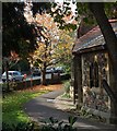
St Alban's Hall, Westbury Park
The building appears on the right of Image and is on the corner of Bayswater Avenue (behind camera) and Coldharbour Road, the B4468 (in the background).
Image: © Derek Harper
Taken: 26 Oct 2015
0.03 miles
6
Ordnance Survey Cut Mark
This OS cut mark can be found on No72 Coldharbour Road. It marks a point 89.581m above mean sea level.
Image: © Adrian Dust
Taken: 20 Jan 2020
0.04 miles
7
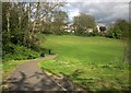
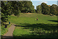
Redland Green park
From near the St Oswald's Road entrance. The houses ahead are on Cossins Road.
Image: © Derek Harper
Taken: 30 Apr 2015
0.05 miles
8
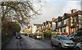
Cossins Road, Westbury Park
The semi-detached houses, which face Redland Green, are succeeded by the white Etloe Evangelical Church.
Image: © Derek Harper
Taken: 4 Jan 2016
0.05 miles
9
Ordnance Survey Cut Mark
This OS cut mark can be found on the wall of No6 Cossins Road. It marks a point 84.317m above mean sea level.
Image: © Adrian Dust
Taken: 20 Jan 2020
0.05 miles
10
Redland Green
See Image; the houses on Cossins Road are obscured by leaves although autumn is on its way.
Image: © Derek Harper
Taken: 3 Oct 2018
0.05 miles