IMAGES TAKEN NEAR TO
Westbury Park, BRISTOL, BS6 7JA
Introduction
This page details the photographs taken nearby to Westbury Park, BS6 7JA by members of the Geograph project.
The Geograph project started in 2005 with the aim of publishing, organising and preserving representative images for every square kilometre of Great Britain, Ireland and the Isle of Man.

There are currently over 7.5m images from over14,400 individuals and you can help contribute to the project by visiting https://www.geograph.org.uk
Image Map
Images are licensed for reuse under creativecommons.org/licenses/by-sa/2.0
Notes
- Clicking on the map will re-center to the selected point.
- The higher the marker number, the further away the image location is from the centre of the postcode.
Image Listing (132 Images Found)
Images are licensed for reuse under creativecommons.org/licenses/by-sa/2.0
Image
Details
Distance
1
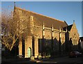
Westbury Park Methodist Church
Also shown in Image The church, which dates from 1890 http://www.churchcrawler.pwp.blueyonder.co.uk/bristol3/wesleyan.htm , is on the corner of Etloe Road and Berkeley Road (shown).
Image: © Derek Harper
Taken: 27 Dec 2014
0.03 miles
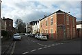
2
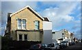
Etloe Road, Westbury Park
From the junction with Berkeley Road (left).
Image: © Derek Harper
Taken: 3 Feb 2016
0.03 miles
3
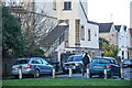
Bristol : Queen Victoria Road
Looking towards Queen Victoria Road.
Image: © Lewis Clarke
Taken: 22 Feb 2024
0.04 miles
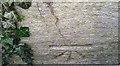
4
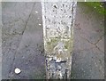
Ordnance Survey Cut Mark
This OS cut mark can be found on a concrete post at the end of Queen Victoria Road. It marks a point 87.697m above mean sea level.
Image: © Adrian Dust
Taken: 17 Jan 2020
0.04 miles
5

Westbury Park Church
Methodist church and home of the White Trees Preschool nursery
Image: © Eirian Evans
Taken: 3 Feb 2016
0.04 miles
7
Queen Victoria Road, Westbury Park
From beside the house whose windows are shown in Image], looking across Etloe Street.
Image: © Derek Harper
Taken: 3 Feb 2016
0.04 miles
8

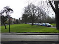
Bristol : The Granny Downs
A grassy area off Westbury Park.
Image: © Lewis Clarke
Taken: 22 Feb 2024
0.05 miles
9
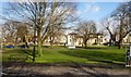
Westbury Park from Westbury Road, Bristol
Image: © Ruth Sharville
Taken: 18 Mar 2011
0.05 miles
10
Ordnance Survey Cut Mark
This OS cut mark can be found on the wall NE side of Etloe Road. It marks a point 85.475m above mean sea level.
Image: © Adrian Dust
Taken: 17 Jan 2020
0.05 miles