IMAGES TAKEN NEAR TO
Old School Close, BRISTOL, BS6 7EA
Introduction
This page details the photographs taken nearby to Old School Close, BS6 7EA by members of the Geograph project.
The Geograph project started in 2005 with the aim of publishing, organising and preserving representative images for every square kilometre of Great Britain, Ireland and the Isle of Man.

There are currently over 7.5m images from over14,400 individuals and you can help contribute to the project by visiting https://www.geograph.org.uk
Image Map
Images are licensed for reuse under creativecommons.org/licenses/by-sa/2.0
Notes
- Clicking on the map will re-center to the selected point.
- The higher the marker number, the further away the image location is from the centre of the postcode.
Image Listing (367 Images Found)
Images are licensed for reuse under creativecommons.org/licenses/by-sa/2.0
Image
Details
Distance
2
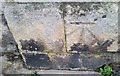
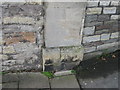
Ordnance Survey Cut Mark
This OS cut mark can be found on the wall of Redland School. It marks a point 60.463m above mean sea level.
Image: © Adrian Dust
Taken: 24 Nov 2016
0.02 miles
3
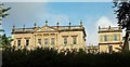
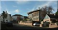
Redland Court
Tricky to get a clear view of this building; Ian's view in Image probably shows more of it from further away. I refer you to his excellent description of the history of the building. Here you can see the upper part of the facade, with a "tetrastyle-in-antis Ionic portico" https://www.historicengland.org.uk/listing/the-list/list-entry/1291739 (four columns with antae, or supporting columns, on either side). Above is a modillion pediment, with "7 good urns" on the balustrade.
Image: © Derek Harper
Taken: 28 Sep 2017
0.03 miles
4
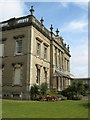
Redland Court
The mansion house at Redland High School for girls.
Image: © George Evans
Taken: 8 Sep 2007
0.03 miles
5
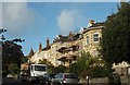
Junction of Kersteman Road and Redland Court Road
The striking house on the right was the winner of a Bristol Civic Society Environmental award in 2007. Across the junction is part of Redland High School.
Image: © Derek Harper
Taken: 28 Oct 2017
0.03 miles
6
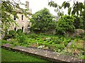
Knot garden, Redland Court
This garden with box hedges dates originally from 1732 http://www.parksandgardens.org/places-and-people/site/2782 . Redland Court is now Redland High School for Girls. Seen from Woodstock Road.
Image: © Derek Harper
Taken: 4 Aug 2013
0.04 miles
7
Glentworth Road, Redland
Semi-detached houses on the north side of the road.
Image: © Derek Harper
Taken: 28 Sep 2017
0.04 miles
8
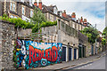
Redland Court Road
Street art adorning some hoardings across a piece of derelict land in Redland Court Road, with houses in Woodstock Road in the background.
Image: © Ian Capper
Taken: 25 Jun 2017
0.05 miles
9
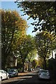
Limerick Road, Bristol
From the junction with Kersteman Road at the top of the tree-lined road.
Image: © Derek Harper
Taken: 28 Oct 2017
0.05 miles
10

Garden globes, Redland
An advantage of a rainy day is the enhanced reflections, such as on these shiny spheres in a garden in Clarendon Road.
Image: © Derek Harper
Taken: 24 Dec 2021
0.06 miles