IMAGES TAKEN NEAR TO
Salisbury Road, BRISTOL, BS6 7AR
Introduction
This page details the photographs taken nearby to Salisbury Road, BS6 7AR by members of the Geograph project.
The Geograph project started in 2005 with the aim of publishing, organising and preserving representative images for every square kilometre of Great Britain, Ireland and the Isle of Man.

There are currently over 7.5m images from over14,400 individuals and you can help contribute to the project by visiting https://www.geograph.org.uk
Image Map
Images are licensed for reuse under creativecommons.org/licenses/by-sa/2.0
Notes
- Clicking on the map will re-center to the selected point.
- The higher the marker number, the further away the image location is from the centre of the postcode.
Image Listing (222 Images Found)
Images are licensed for reuse under creativecommons.org/licenses/by-sa/2.0
Image
Details
Distance
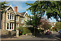
1
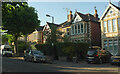
Salisbury Road, Redland
A tree-lined residential road of semi-detached houses.
Image: © Derek Harper
Taken: 19 Jul 2021
0.02 miles
2
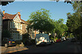
Salisbury Road, Redland
Looking right from Image
Image: © Derek Harper
Taken: 19 Jul 2021
0.03 miles
3
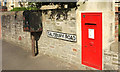
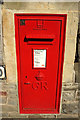
Postbox, Redland
Placing Image] in a bit more context.
Image: © Derek Harper
Taken: 26 Sep 2018
0.04 miles
4
Houses on Northumberland Road, Redland
On the stretch between Carnarvon Road and Kersteman Road.
Image: © Derek Harper
Taken: 19 Jul 2021
0.05 miles
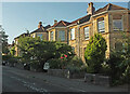
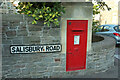
5
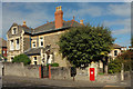
House and postbox, Salisbury Road, Redland
George V postbox BS6 241 is by the junction with Carnarvon Road.
Image: © Derek Harper
Taken: 26 Sep 2018
0.05 miles
6
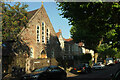
St Catherine's Court, Redland
An interesting history at http://www.churchcrawler.co.uk/kathred.htm : "built in 1898 ... as a parish hall, to serve as a temporary church, but was consecrated in 1931. The permanent church never followed and the church was closed in 1953 ... It was used by the BBC as a television Studio for a while, with programmes being broadcast from it. Later it was used by the BBC as a scenery construction workshop". Now flats. See also Image
Image: © Derek Harper
Taken: 19 Jul 2021
0.05 miles
7
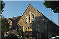
St Catherine's Court, Redland
The former St Katherine's church on Salisbury Road is also shown at Image http://www.churchcrawler.co.uk/kathred.htm
Image: © Derek Harper
Taken: 19 Jul 2021
0.05 miles
8
Carnarvon Road, Redland
On the right, Carnarvon Road crosses Salisbury Road.
Image: © Derek Harper
Taken: 26 Sep 2018
0.05 miles
9
Postbox, Redland
Image: © Derek Harper
Taken: 26 Sep 2018
0.05 miles
10
Postbox, Redland
George V postbox BS6 241 is by the crossroads of Carnarvon Road and Salisbury Road, shown in Image
Image: © Derek Harper
Taken: 19 Jul 2021
0.05 miles