IMAGES TAKEN NEAR TO
Zetland Road, BRISTOL, BS6 7AG
Introduction
This page details the photographs taken nearby to Zetland Road, BS6 7AG by members of the Geograph project.
The Geograph project started in 2005 with the aim of publishing, organising and preserving representative images for every square kilometre of Great Britain, Ireland and the Isle of Man.

There are currently over 7.5m images from over14,400 individuals and you can help contribute to the project by visiting https://www.geograph.org.uk
Image Map
Images are licensed for reuse under creativecommons.org/licenses/by-sa/2.0
Notes
- Clicking on the map will re-center to the selected point.
- The higher the marker number, the further away the image location is from the centre of the postcode.
Image Listing (281 Images Found)
Images are licensed for reuse under creativecommons.org/licenses/by-sa/2.0
Image
Details
Distance
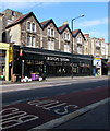
2
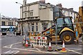
Roadworks on Zetland Road
An obstruction at a busy junction, where Cranbrook Road meets Zetland Road immediately west of its junction with Gloucester Road (left). The building behind, once the Midland bank, is currently an ice cream parlour.
Image: © Derek Harper
Taken: 18 Mar 2016
0.02 miles
3
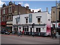
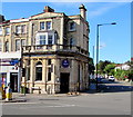
Prince of Wales public house
The Prince of Wales public house stands on the corner of Zetland Road, Gloucester Road and Cheltenham Road. It was totally refurbished in 2002.
Image: © Sharon Loxton
Taken: 2 Aug 2006
0.02 miles
4
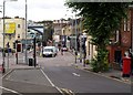
Junction in Bishopston
The junction at which Gloucester Road, arriving from the left, becomes Cheltenham Road, heading under the railway bridge towards Bristol city centre. Crossing other through routes here means that this is always a busy junction. The former bank in Image is mostly hidden by the tree on the right. In the foreground is Elton Road.
Image: © Derek Harper
Taken: 10 Jul 2009
0.02 miles
5
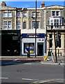
William Hill, 241 Cheltenham Road, Bristol
Betting shop alongside the A38 Cheltenham Road.
Image: © Jaggery
Taken: 13 Sep 2018
0.02 miles
6
La Guinguette, 243 Cheltenham Road, Bristol
French bistro on the corner of Zetland Road.
Image: © Jaggery
Taken: 13 Sep 2018
0.02 miles
7
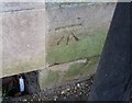
Ordnance Survey Cut Mark
This OS cut mark can be found on the old Bank building west side of Gloucester Road. It marks a point 26.713m above mean sea level.
Image: © Adrian Dust
Taken: 14 Mar 2020
0.02 miles
8
Jasmine, Bristol
Fast food takeaway at 235 Cheltenham Road.
Image: © Jaggery
Taken: 13 Sep 2018
0.02 miles
9
Bishops Tavern, Bristol
A Greene King pub at 225-229 Cheltenham Road. https://www.geograph.org.uk/photo/5923348 to the name sign on the left.
Image: © Jaggery
Taken: 13 Sep 2018
0.02 miles
10
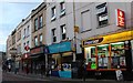
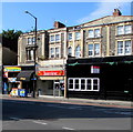
Shops on Cheltenham Road, Montpelier
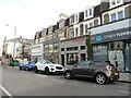
Not knowing Bristol many of the roads in the inner area like this remind me of south London, places like Sydenham, Tooting, Brixton or Herne Hill. Many cities are similar to another, such as Oxford and a part of Reading, which are far closer and built by many of the same people. South London has a character of its own and I felt this a lot in the few hours I spent travelling around Bristol.
Image: © David Howard
Taken: 1 Jun 2019
0.03 miles