IMAGES TAKEN NEAR TO
Zetland Road, BRISTOL, BS6 7AE
Introduction
This page details the photographs taken nearby to Zetland Road, BS6 7AE by members of the Geograph project.
The Geograph project started in 2005 with the aim of publishing, organising and preserving representative images for every square kilometre of Great Britain, Ireland and the Isle of Man.

There are currently over 7.5m images from over14,400 individuals and you can help contribute to the project by visiting https://www.geograph.org.uk
Image Map
Images are licensed for reuse under creativecommons.org/licenses/by-sa/2.0
Notes
- Clicking on the map will re-center to the selected point.
- The higher the marker number, the further away the image location is from the centre of the postcode.
Image Listing (271 Images Found)
Images are licensed for reuse under creativecommons.org/licenses/by-sa/2.0
Image
Details
Distance
1
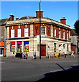
Former bank branch on a Bristol corner
On the corner of Zetland Road and Elton Road.
Image: © Jaggery
Taken: 13 Sep 2018
0.01 miles
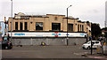
2
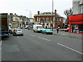
Gloucester Road, Bishopston, Bristol
The building in the centre of the image with the graffiti on it looks as though it was a bank in a previous life. Now it is home to a branch of mobile phone vendors.
Image: © Brian Robert Marshall
Taken: 17 Feb 2009
0.01 miles
3
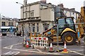
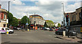
Roadworks on Zetland Road
An obstruction at a busy junction, where Cranbrook Road meets Zetland Road immediately west of its junction with Gloucester Road (left). The building behind, once the Midland bank, is currently an ice cream parlour.
Image: © Derek Harper
Taken: 18 Mar 2016
0.02 miles
4
La Guinguette, 243 Cheltenham Road, Bristol
French bistro on the corner of Zetland Road.
Image: © Jaggery
Taken: 13 Sep 2018
0.02 miles
5
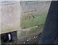
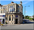
Ordnance Survey Cut Mark
This OS cut mark can be found on the old Bank building west side of Gloucester Road. It marks a point 26.713m above mean sea level.
Image: © Adrian Dust
Taken: 14 Mar 2020
0.02 miles
6
Junction on Gloucester Road, Bristol
Just north of The Arches. The A38 Gloucester Road swings right here past Sainsbury's Local. On the left is the former bank better seen in Image Elton Road, one-way to begin with, climbs past it to the left.
Image: © Derek Harper
Taken: 7 May 2019
0.02 miles
7
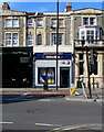
William Hill, 241 Cheltenham Road, Bristol
Betting shop alongside the A38 Cheltenham Road.
Image: © Jaggery
Taken: 13 Sep 2018
0.02 miles
8

Prince of Wales name sign, 5 Gloucester Road, Bristol
At the southern edge of this https://www.geograph.org.uk/photo/213662 pub.
Image: © Jaggery
Taken: 13 Sep 2018
0.03 miles
9

Clouds over Maplin, Bristol
A sunnier photo than Image but the premises are firmly closed. However, there's a dramatic sky overhead, with streets of cirrus clouds.
Image: © Derek Harper
Taken: 12 Sep 2018
0.03 miles
10
Ex-Maplin, Gloucester Road, Bristol
All is desolation at the closed store shown in Image
Image: © Derek Harper
Taken: 12 Sep 2018
0.03 miles