IMAGES TAKEN NEAR TO
Redland Hill, BRISTOL, BS6 6UU
Introduction
This page details the photographs taken nearby to Redland Hill, BS6 6UU by members of the Geograph project.
The Geograph project started in 2005 with the aim of publishing, organising and preserving representative images for every square kilometre of Great Britain, Ireland and the Isle of Man.

There are currently over 7.5m images from over14,400 individuals and you can help contribute to the project by visiting https://www.geograph.org.uk
Image Map
Images are licensed for reuse under creativecommons.org/licenses/by-sa/2.0
Notes
- Clicking on the map will re-center to the selected point.
- The higher the marker number, the further away the image location is from the centre of the postcode.
Image Listing (300 Images Found)
Images are licensed for reuse under creativecommons.org/licenses/by-sa/2.0
Image
Details
Distance
1
Obelisk in building site
The memorial https://www.historicengland.org.uk/listing/the-list/list-entry/1246120 to the much-mourned Princess Charlotte, who died in 1817 aged 21, is in the centre of a building site on land beside Queen Victoria House, itself shrouded in the background. 65 apartments are being created; "The Vincent" will be completed in Autumn 2018 https://www.pegasuslife.co.uk/portfolio/clifton-bristol . This view is from Grove Road.
Image: © Derek Harper
Taken: 29 Oct 2017
0.03 miles
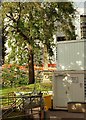
2

Once there was a garage ...
Now there's a building site.
Image: © Anthony O'Neil
Taken: 28 Jun 2015
0.03 miles
3
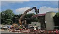
Demolition of filling station on Blackboy Hill
During transformation from an Esso to an Asda outlet. By a curious coincidence, I patronised this very filling station today a few hours before submitting this, nearly five months after taking the photo, though I snobbishly try to avoid supermarket chains with four-letter names.
Image: © Derek Harper
Taken: 25 Jun 2015
0.03 miles
4
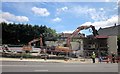
Demolition of filling station on Blackboy Hill
Another view of Image], with the rather sinister pulveriser at work on the old canopy.
Image: © Derek Harper
Taken: 25 Jun 2015
0.03 miles
5
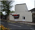
Simply Spice, Clifton, Bristol
Indian takeaway at 215 Whiteladies Road.
Image: © Jaggery
Taken: 7 May 2012
0.03 miles
6
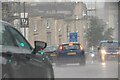
Bristol : Redland - Whiteladies Road A4018
Looking along Whiteladies Road on a wet afternoon.
Image: © Lewis Clarke
Taken: 11 Jul 2023
0.03 miles
7
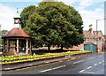
Blackboy Hill Area - BS8
As a result of the one-way traffic flow system in this vicinity Westbury Road carries traffic down this incline in a southeasterly direction to join Whiteladies Road (A4018). A clock-topped war memorial is set in a 'green island' and a 1940s-50s cast iron urinal sits at the junction with Cabman's Lane (behind the trees). The urinal has been identified as having been manufactured at the Saracen Foundry in Glasgow by Walter Macfarlane & Co. It is still functional.
Image: © David Hallam-Jones
Taken: 31 Jul 2012
0.04 miles
8
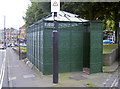
Victorian utility
The cast iron urinal is now a thing of rarity. Bristol had three such examples of Victorian providence, and this one is Grade II listed - and apparently still open to customers.
Originally it appears to have been installed a little further to the south in around the early 1880s, before arriving here a few years later. See Image] for a detail.
Image: © Neil Owen
Taken: 7 Sep 2017
0.04 miles
9
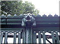
Iron gargoyle on the gentlemen's convenience
The cast iron urinal at the top of Blackboy Hill dates from around the 1880s; it was made by W. MacFarlane & Co. Ltd’s Saracen Foundry, Glasgow. See Image] for a wider view.
Image: © Neil Owen
Taken: 7 Sep 2017
0.04 miles
10

Doorway in wall, Grove Road, Bristol
Temptingly ajar, but the bins inside make it rather less romantic.
Image: © Derek Harper
Taken: 29 Oct 2017
0.04 miles