IMAGES TAKEN NEAR TO
Chapel Green Lane, BRISTOL, BS6 6UA
Introduction
This page details the photographs taken nearby to Chapel Green Lane, BS6 6UA by members of the Geograph project.
The Geograph project started in 2005 with the aim of publishing, organising and preserving representative images for every square kilometre of Great Britain, Ireland and the Isle of Man.

There are currently over 7.5m images from over14,400 individuals and you can help contribute to the project by visiting https://www.geograph.org.uk
Image Map
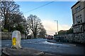
Images are licensed for reuse under creativecommons.org/licenses/by-sa/2.0
Notes
- Clicking on the map will re-center to the selected point.
- The higher the marker number, the further away the image location is from the centre of the postcode.
Image Listing (339 Images Found)
Images are licensed for reuse under creativecommons.org/licenses/by-sa/2.0
Image
Details
Distance
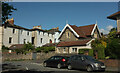
1

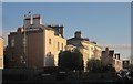
Houses on Chapel Green Lane, Redland
Between them can be seen the listed Redland Hill House, now the Bristol Steiner School: "1761. By James Bridges ... Designed as a semi-detached pair with a matching bay at the opposite end, and as such a very rare design. The other end was demolished in 1933" https://historicengland.org.uk/listing/the-list/list-entry/1218972 . See also Image
Image: © Derek Harper
Taken: 25 May 2021
0.04 miles
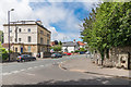
2

Houses, Lower Redland Road
A pair of semis by the junction with Chapel Green Lane which has been given the priority.
Image: © Derek Harper
Taken: 25 May 2021
0.04 miles
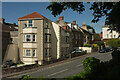
3
Houses on Lower Redland Road
The central pair with the "2-storey porches with tented, leaded roofs" are listed http://list.english-heritage.org.uk/resultsingle.aspx?uid=1282218&searchtype=mapsearch .
Image: © Derek Harper
Taken: 27 Dec 2014
0.04 miles
4
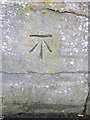
Ordnance Survey Cut Mark
This OS cut mark can be found on the gatepost of No154 Redland Road. It marks a point 82.701m above mean sea level.
Image: © Adrian Dust
Taken: 5 Mar 2016
0.04 miles
5
Bristol : Lower Redland Road
Looking along the road.
Image: © Lewis Clarke
Taken: 22 Feb 2024
0.04 miles
6
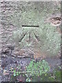
Ordnance Survey Cut Mark
This OS cut mark can be found on the gatepost of No36 Lower Redland Road. It marks a point 73.058m above mean sea level.
Image: © Adrian Dust
Taken: 1 Mar 2016
0.04 miles
7
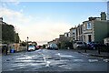
Bristol : Redland Road
Looking along Redland Road from Chapel Green Lane.
Image: © Lewis Clarke
Taken: 22 Feb 2024
0.04 miles
8
Redland Road
Looking along Redland Road from Redland Green Road. On the far right is the memorial drinking fountain in Image
Image: © Ian Capper
Taken: 25 Jun 2017
0.04 miles
9
Houses, Redland Road
Looking right from Image This section of Redland Road is much more of a hill than the nearby road called "Redland Hill", though that is roughly on top of the hill.
Image: © Derek Harper
Taken: 25 May 2021
0.05 miles
10
Houses, Lower Redland Road
The rather charming cottage is by the junction with Elm Lane.
Image: © Derek Harper
Taken: 25 May 2021
0.05 miles