IMAGES TAKEN NEAR TO
Elm Lane, BRISTOL, BS6 6TX
Introduction
This page details the photographs taken nearby to Elm Lane, BS6 6TX by members of the Geograph project.
The Geograph project started in 2005 with the aim of publishing, organising and preserving representative images for every square kilometre of Great Britain, Ireland and the Isle of Man.

There are currently over 7.5m images from over14,400 individuals and you can help contribute to the project by visiting https://www.geograph.org.uk
Image Map
Images are licensed for reuse under creativecommons.org/licenses/by-sa/2.0
Notes
- Clicking on the map will re-center to the selected point.
- The higher the marker number, the further away the image location is from the centre of the postcode.
Image Listing (354 Images Found)
Images are licensed for reuse under creativecommons.org/licenses/by-sa/2.0
Image
Details
Distance
1
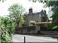
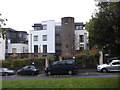
Elm Lane & Malvern House
In the 1960's this was an area dominated by buildings belonging to Redland College, a teacher training establishment associated with Bristol University. Behind the stone wall is Malvern House, once a women's hall of residence, and supposedly out of bounds to male students. [No further details necessary.] The modern building glimpsed to the right must be on the site of the former college refectory where many an inedible meal was served up for students, some of which might have been seen escaping to the nearby Chiquita restaurant on Blackboy Hill.
Image: © Gordon Hatton
Taken: 24 May 2017
0.02 miles
2
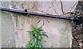
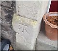
Ordnance Survey Cut Mark
This OS cut mark can be found on No22 Elm Lane. It marks a point 89.130m above mean sea level.
Image: © Adrian Dust
Taken: 16 Jan 2020
0.02 miles
3
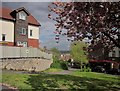
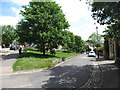
Green, Redland
A view across part of a small steep triangular green from Grove Road; the road ahead is Elm Lane.
Image: © Derek Harper
Taken: 30 Apr 2015
0.03 miles
4
Green by Grove Road, Bristol
The green is also shown in Image On the other side is Elm Lane.
Image: © Derek Harper
Taken: 15 Apr 2022
0.03 miles
5
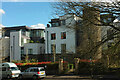
Modern block of flats on Elm Lane, Redland
Image: © Eirian Evans
Taken: 15 Oct 2014
0.03 miles
6
Houses on Elm Lane, Redland
Attributable to the architect of Image], which is next door but one or two.
Image: © Derek Harper
Taken: 15 Apr 2022
0.04 miles
7
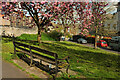
Green triangle by Elm Lane
On a fine day in the sixties this small green area would have been crowded with students lolling around in the sun and wondering if Ruby's afternoon history lecture in nearby Redland College buildings would be worth the bother. Nowadays, a small oasis of calm not far from the bustle of Blackboy Hill and Whiteladies Road.
Image: © Gordon Hatton
Taken: 24 May 2017
0.04 miles
8
Ordnance Survey Cut Mark
This OS cut mark can be found on No1 Shrubbery Cottages. It marks a point 80.156m above mean sea level.
Image: © Adrian Dust
Taken: 16 Jan 2020
0.04 miles
9
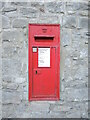
Grove Road letterbox
A Victorian box by W.T. Allen in the wall on Grove Road. See Image] for a wider view.
Image: © Neil Owen
Taken: 22 Mar 2022
0.04 miles
10
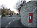
Grove Road
An old letterbox is set into the wall. See Image] for a closer look.
Image: © Neil Owen
Taken: 22 Mar 2022
0.04 miles