IMAGES TAKEN NEAR TO
Greenway Road, BRISTOL, BS6 6SG
Introduction
This page details the photographs taken nearby to Greenway Road, BS6 6SG by members of the Geograph project.
The Geograph project started in 2005 with the aim of publishing, organising and preserving representative images for every square kilometre of Great Britain, Ireland and the Isle of Man.

There are currently over 7.5m images from over14,400 individuals and you can help contribute to the project by visiting https://www.geograph.org.uk
Image Map
Images are licensed for reuse under creativecommons.org/licenses/by-sa/2.0
Notes
- Clicking on the map will re-center to the selected point.
- The higher the marker number, the further away the image location is from the centre of the postcode.
Image Listing (390 Images Found)
Images are licensed for reuse under creativecommons.org/licenses/by-sa/2.0
Image
Details
Distance
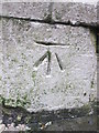
1
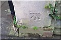
Ordnance Survey Cut Mark
This OS cut mark can be found on the gatepost of No7 Greenway Road. It marks a point 71.281m above mean sea level.
Image: © Adrian Dust
Taken: 16 Jan 2020
0.01 miles
2
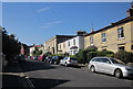
Greenway Road, Redland
From near the junction with Redland Park.
Image: © Derek Harper
Taken: 23 Jun 2015
0.02 miles
3
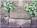
Ordnance Survey Cut Mark
This OS cut mark can be found on the SW side of Exeter Buildings. It marks a point 74.972m above mean sea level.
Image: © Adrian Dust
Taken: 16 Jan 2020
0.04 miles
4
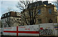
Graffiti on hoardings, Redland Park
Wishful thinking from the previous July. Perhaps the failure to complete the work involved at this substantial detached house is a consequence of the despair felt when "it" didn't quite come home.
Image: © Derek Harper
Taken: 26 Dec 2021
0.05 miles
5
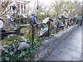
"The fence", Burlington Road
Sculptures by Julian Warren, a British artist whose sculptures, many reflecting the natural world, can be seen on the streets of London, Bristol and elsewhere. ‘The fence’ marking the boundary of Julian Warren's home has become a permanent gallery, a local landmark that entertains both the artist and public.
Image: © Eirian Evans
Taken: 20 Feb 2018
0.06 miles
6
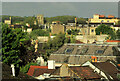
View over Woolcot Park
From Clarendon Road. The twin towers left of centre belong to St John's Place, the former Church of St John with St Anselm https://historicengland.org.uk/listing/the-list/list-entry/1203518 , now a nursery; see also http://www.geograph.org.uk/search.php?i=134485989 .
Image: © Derek Harper
Taken: 22 May 2021
0.06 miles
7
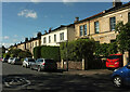
Elgin Park, Redland
Semis on the west side of the road.
Image: © Derek Harper
Taken: 25 May 2021
0.06 miles
8
St. John?s Primary School, Redland
This is the infant site, housed recently in the former Redland Police Station. It seems a bit odd for young children to move into a three-storey building, but it is a striking edifice. See also Image The tastefully painted garage belongs to a property on East Shrubbery.
Image: © Derek Harper
Taken: 25 Jun 2015
0.06 miles
9
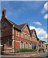
St John?s Primary School, Redland
The façade of Image, a school in a former police station, from the other direction.
Image: © Derek Harper
Taken: 25 Jun 2015
0.06 miles
10
Ordnance Survey Cut Mark
This OS cut mark can be found on the gatepost of 34A Lower Redland Road. It marks a point 73.850m above mean sea level.
Image: © Adrian Dust
Taken: 1 Mar 2016
0.06 miles