IMAGES TAKEN NEAR TO
Elgin Park, BRISTOL, BS6 6RU
Introduction
This page details the photographs taken nearby to Elgin Park, BS6 6RU by members of the Geograph project.
The Geograph project started in 2005 with the aim of publishing, organising and preserving representative images for every square kilometre of Great Britain, Ireland and the Isle of Man.

There are currently over 7.5m images from over14,400 individuals and you can help contribute to the project by visiting https://www.geograph.org.uk
Image Map
Images are licensed for reuse under creativecommons.org/licenses/by-sa/2.0
Notes
- Clicking on the map will re-center to the selected point.
- The higher the marker number, the further away the image location is from the centre of the postcode.
Image Listing (423 Images Found)
Images are licensed for reuse under creativecommons.org/licenses/by-sa/2.0
Image
Details
Distance
1

Sunset over North Bristol
Blurred clouds with angry colours over clearly defined trees and buildings in this view looking right from Image
Image: © Derek Harper
Taken: 16 Mar 2022
0.02 miles
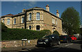
2
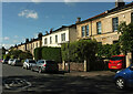
Elgin Park, Redland
Semis on the west side of the road.
Image: © Derek Harper
Taken: 25 May 2021
0.03 miles
3
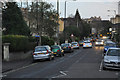
Bristol : Elgin Road
A residential road seen from Lower Redland Road.
Image: © Lewis Clarke
Taken: 24 Mar 2015
0.03 miles
4
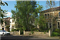
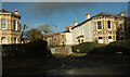
Houses on Napier Road, Redland
There are only ten properties on the road; here are three, which, along with Image], constitute all those on the west side of the road. The gate piers match those on Grove Park Image
Image: © Derek Harper
Taken: 25 May 2021
0.03 miles
5
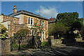
House on Napier Road, Redland
An attractive detached house, built of "red and ochre ragstone, with limestone
details" https://www.bristol.gov.uk/documents/20182/33832/cotham-redland-character-appaisal.pdf/5f7556f6-1da3-4743-8d2c-10ca1597b323 , on the west side of the road.
Image: © Derek Harper
Taken: 25 May 2021
0.03 miles
6
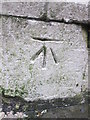
Ordnance Survey Cut Mark
This OS cut mark can be found on the gatepost of 34A Lower Redland Road. It marks a point 73.850m above mean sea level.
Image: © Adrian Dust
Taken: 1 Mar 2016
0.06 miles
7
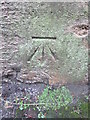
Ordnance Survey Cut Mark
This OS cut mark can be found on the gatepost of No36 Lower Redland Road. It marks a point 73.058m above mean sea level.
Image: © Adrian Dust
Taken: 1 Mar 2016
0.06 miles
8
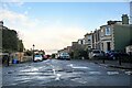
Bristol : Lower Redland Road
Looking along the road.
Image: © Lewis Clarke
Taken: 22 Feb 2024
0.06 miles
9
Napier Road, Redland
The house on the left is the one shown in Image, so this shows the eastern side of the road across the junction with Clyde Road.
Image: © Derek Harper
Taken: 26 Dec 2021
0.06 miles
10
House, Napier Road
Though its address is Clyde Road, the road just behind the camera.
Image: © Derek Harper
Taken: 25 May 2021
0.06 miles