IMAGES TAKEN NEAR TO
Redland Road, BRISTOL, BS6 6RA
Introduction
This page details the photographs taken nearby to Redland Road, BS6 6RA by members of the Geograph project.
The Geograph project started in 2005 with the aim of publishing, organising and preserving representative images for every square kilometre of Great Britain, Ireland and the Isle of Man.

There are currently over 7.5m images from over14,400 individuals and you can help contribute to the project by visiting https://www.geograph.org.uk
Image Map
Images are licensed for reuse under creativecommons.org/licenses/by-sa/2.0
Notes
- Clicking on the map will re-center to the selected point.
- The higher the marker number, the further away the image location is from the centre of the postcode.
Image Listing (372 Images Found)
Images are licensed for reuse under creativecommons.org/licenses/by-sa/2.0
Image
Details
Distance
1
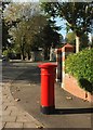
Postbox, Redland Road
Victorian postbox BS6 272 is by the junction with Redland Court Road and Carnarvon Road. See also Image In the background are the gates shown in Image
Image: © Derek Harper
Taken: 28 Oct 2017
0.01 miles
2
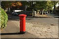
Postbox, Redland Road
Another view of Victorian postbox BS6 272, shown in Image Redland Road is on the right, and Carnarvon Road on the left.
Image: © Derek Harper
Taken: 28 Oct 2017
0.01 miles
3
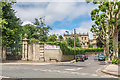
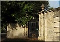
Redland Court
Mansion built in 1732-5 by local architect John Strachan for John Cossins, the son of a London grocer who married the daughter of a Bristol merchant and moved to Redland. From the mid 19th Century it was home to Bristol banker (and High Sheriff of Bristol from 1855-6), George O Edwards. After his death in 1883, it was sold and from 1885 it became home to Redland High School for Girls which had been founded 3 years earlier. This role ceased in the summer of 2017, with the school merging with Red Maids' School, with the combined school, to be known as Redmaids' High School, being based at the latter's site in Westbury-on-Trym. The Redland Court site has been sold to developers.
The main building is grade II* listed as are the gates (on the left of the photo) - see www.historicengland.org.uk/listing/the-list/list-entry/1291739 and www.historicengland.org.uk/listing/the-list/list-entry/1291745 respectively.
Image: © Ian Capper
Taken: 25 Jun 2017
0.02 miles
4
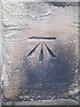
Ordnance Survey Cut Mark
This OS cut mark can be found on the NE face of Redland Road. It marks a point 46.333m above mean sea level.
Image: © Adrian Dust
Taken: 1 Mar 2016
0.03 miles
5
Gates to Redland Court
Also shown in Image; grade II* listed. "1735. By John Strachan. Ironwork by Nathaniel Arthur" https://www.historicengland.org.uk/listing/the-list/list-entry/1291745 .
Image: © Derek Harper
Taken: 28 Sep 2017
0.03 miles
6

Frosted blocks, Redland Court
The only reference I can trace to "frosted blocks" on a listed building description https://www.historicengland.org.uk/listing/the-list/list-entry/1291745 in England, and therefore, it would appear, a fairly unusual form of decoration.
Image: © Derek Harper
Taken: 22 Feb 2018
0.03 miles
7
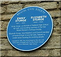
Blue plaque, Redland Court
By the gatepier shown in Image Emily and Elizabeth Sturge were significant figures in the early development of Redland High School for Girls. The building has now been converted into housing.
Image: © Derek Harper
Taken: 9 Sep 2021
0.03 miles
8
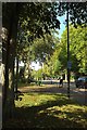
Redland Road. Redland
At the junction with Grove Park (left), succeeded by a pedestrian crossing, and then by the junction with Redland Grove. Image shows the trees overhead hereabouts.
Image: © Derek Harper
Taken: 28 Sep 2017
0.03 miles
10
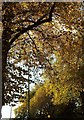
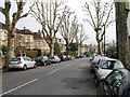
Autumn leaves, Redland
Looking in the other direction from Image], with the tell-tale belisha beacon at the bottom indicating a pedestrian crossing on Redland Road.
Image: © Derek Harper
Taken: 24 Oct 2015
0.04 miles