IMAGES TAKEN NEAR TO
Melville Road, BRISTOL, BS6 6PA
Introduction
This page details the photographs taken nearby to Melville Road, BS6 6PA by members of the Geograph project.
The Geograph project started in 2005 with the aim of publishing, organising and preserving representative images for every square kilometre of Great Britain, Ireland and the Isle of Man.

There are currently over 7.5m images from over14,400 individuals and you can help contribute to the project by visiting https://www.geograph.org.uk
Image Map
Images are licensed for reuse under creativecommons.org/licenses/by-sa/2.0
Notes
- Clicking on the map will re-center to the selected point.
- The higher the marker number, the further away the image location is from the centre of the postcode.
Image Listing (370 Images Found)
Images are licensed for reuse under creativecommons.org/licenses/by-sa/2.0
Image
Details
Distance
1
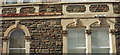
Details of house, Redland
Heads and decorative capitals adorn the windows of this house, which is actually on Collingwood Road, but this side faces Melville Road.
Image: © Derek Harper
Taken: 3 Apr 2018
0.01 miles
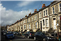
2
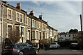
Cowper Road, Redland
The southeastern end of the terrace shown in Image], with an abrupt change in height for the last two houses, by a short cul-de-sac beyond the junction with Melville Road. Beyond is the railway cutting and the rear of houses on Waverley Road.
Image: © Derek Harper
Taken: 3 Apr 2018
0.01 miles
3
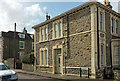
House facing Melville Road, Redland
... but actually on Cowper Road, which is just to the right of the camera.
Image: © Derek Harper
Taken: 3 Apr 2018
0.02 miles
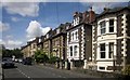
4
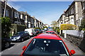
Collingwood Road, Woolcott Park
A residential street where parking is predictably tight.
Image: © Bill Boaden
Taken: 13 Apr 2016
0.03 miles
5
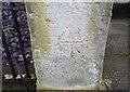
Ordnance Survey Cut Mark
This OS cut mark can be found on the gatepost of No18 Cowper Road. It marks a point 53.636m above mean sea level.
Image: © Adrian Dust
Taken: 14 Mar 2020
0.03 miles
6
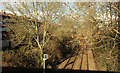
Railway line, Redland
A view from the bridge on Hampton Road, looking in the direction of Redland Station.
Image: © Derek Harper
Taken: 28 Mar 2018
0.03 miles
7
Cowper Road, Redland
Image: © Derek Harper
Taken: 3 Apr 2018
0.04 miles
8
Waverley Road, Bristol
Looking past the junction with St Ronan's Avenue on the left.
Image: © Derek Harper
Taken: 24 Jun 2015
0.04 miles
9
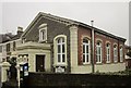
Kingdom Hall of Jehovah's Witnesses, Redland
On Hampton Road by the railway bridge.
Image: © Derek Harper
Taken: 28 Mar 2015
0.04 miles
10
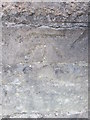
Ordnance Survey Cut Mark
This OS cut mark can be found on the NE parapet of the railway bridge. It marks a point 56m above mean sea level.
Image: © Adrian Dust
Taken: 5 Mar 2016
0.05 miles