IMAGES TAKEN NEAR TO
Ashgrove Road, BRISTOL, BS6 6LZ
Introduction
This page details the photographs taken nearby to Ashgrove Road, BS6 6LZ by members of the Geograph project.
The Geograph project started in 2005 with the aim of publishing, organising and preserving representative images for every square kilometre of Great Britain, Ireland and the Isle of Man.

There are currently over 7.5m images from over14,400 individuals and you can help contribute to the project by visiting https://www.geograph.org.uk
Image Map
Images are licensed for reuse under creativecommons.org/licenses/by-sa/2.0
Notes
- Clicking on the map will re-center to the selected point.
- The higher the marker number, the further away the image location is from the centre of the postcode.
Image Listing (377 Images Found)
Images are licensed for reuse under creativecommons.org/licenses/by-sa/2.0
Image
Details
Distance
1
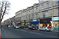
Whiteladies Rd, Bristol
View south down Whiteladies Rd from close to the junction with Redland Park
Image: © Nigel Mykura
Taken: 28 Feb 2009
0.01 miles
2
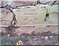
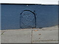
Ordnance Survey Cut Mark
This OS cut mark can be found on the wall of No21 Ashgrove Road. It marks a point 66.587m above mean sea level.
Image: © Adrian Dust
Taken: 16 Jan 2020
0.02 miles
3
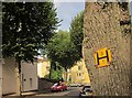
Fire hydrant sign, Woolcott Park
Attached to a tree in Chertsey Road, with the junction with Ashgrove Road in the background.
Image: © Derek Harper
Taken: 22 Sep 2014
0.03 miles
4
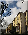
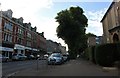
Oakland Road, Redland
Impressive semi-detached villas on this short road, seen from Chertsey Road.
Image: © Derek Harper
Taken: 22 Mar 2015
0.03 miles
5
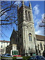
Tyndale Baptist Church
In Whiteladies Road.
Image: © Natasha Ceridwen de Chroustchoff
Taken: 12 Apr 2008
0.03 miles
6
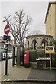
Octagon, Whiteladies Road
Described as a "Gothic Octagon" at http://www.pmsa.org.uk/pmsa-database/13379/ , but without any further explanation. As shown, this is at the corner of Ashgrove Road. The Elizabeth II postbox is number BS6 385.
Image: © Derek Harper
Taken: 23 Feb 2014
0.03 miles
7
Old Boundary Marker on Whiteladies Road, Bristol
Municipal Boundary Marker set in the wall below s shop's window on the southwest side of the junction of the A4018 Whiteladies Road and Chantry Road. Inscribed C B / 1874. 1874 is probably the date when the Bristol County Borough and City boundary was established here.
Milestone Society National ID: GL_BRIS35pb
Image: © Roadside Relics
Taken: 11 Nov 2022
0.04 miles

10
Redland, Oakland Road
Solid Victorian housing.
Image: © Mike Faherty
Taken: 7 Mar 2015
0.05 miles