IMAGES TAKEN NEAR TO
Rokeby Avenue, BRISTOL, BS6 6EL
Introduction
This page details the photographs taken nearby to Rokeby Avenue, BS6 6EL by members of the Geograph project.
The Geograph project started in 2005 with the aim of publishing, organising and preserving representative images for every square kilometre of Great Britain, Ireland and the Isle of Man.

There are currently over 7.5m images from over14,400 individuals and you can help contribute to the project by visiting https://www.geograph.org.uk
Image Map
Images are licensed for reuse under creativecommons.org/licenses/by-sa/2.0
Notes
- Clicking on the map will re-center to the selected point.
- The higher the marker number, the further away the image location is from the centre of the postcode.
Image Listing (347 Images Found)
Images are licensed for reuse under creativecommons.org/licenses/by-sa/2.0
Image
Details
Distance
1
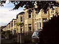
Rokeby Avenue, Redland
The first building is made up of three houses together; the rest of the road is composed of semis.
Image: © Derek Harper
Taken: 21 Sep 2017
0.03 miles
2

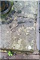
Ordnance Survey Cut Mark
This OS cut mark can be found on the gatepost of No60 Waverley Road. It marks a point 49.713m above mean sea level.
Image: © Adrian Dust
Taken: 14 Mar 2020
0.04 miles
3
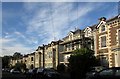
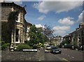
Montrose Avenue, Redland
Sizeable three-storey houses on the residential road.
Image: © Derek Harper
Taken: 21 Sep 2017
0.06 miles
4
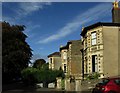
Houses on Ravenswood Road, Redland
Opposite the junction with Montrose Road.
Image: © Derek Harper
Taken: 21 Sep 2017
0.06 miles
5

Cotham Vale, Bristol
From the junction with Trelawney Rd.
Image: © John Lord
Taken: 10 Dec 2010
0.06 miles
6
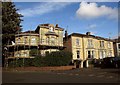
Junction of Waverley Road and Montrose Avenue, Redland
With scaffolding on the corner house, as Waverley Road heads around a double bend to become Meridian Road.
Image: © Derek Harper
Taken: 21 Sep 2017
0.07 miles
7
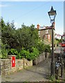
Cotham Vale
Taken at the right andled bend in the street, with George VI postbox BS6 236 on the left and an old lamppost on the right.
Image: © Derek Harper
Taken: 21 Sep 2017
0.08 miles
8
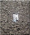
Ordnance Survey Rivet
This OS rivet can be found on the wall in front of No41 Cotham Vale. It marks a point 60.890m above mean sea level.
Image: © Adrian Dust
Taken: 16 Jan 2020
0.08 miles
9
Birthday decoration, Kensington Road
Outside the Kensington Arms; someone was obviously a bit unsteady, understandably.
Image: © Derek Harper
Taken: 30 Apr 2015
0.08 miles
10
St Ronan's Avenue, Bristol
At the junction, clearly, with Kenilworth Road. At the end, St Ronan's Avenue meets Waverley Road at another T junction.
Image: © Derek Harper
Taken: 24 Jun 2015
0.08 miles