IMAGES TAKEN NEAR TO
Cotham Brow, BRISTOL, BS6 6AP
Introduction
This page details the photographs taken nearby to Cotham Brow, BS6 6AP by members of the Geograph project.
The Geograph project started in 2005 with the aim of publishing, organising and preserving representative images for every square kilometre of Great Britain, Ireland and the Isle of Man.

There are currently over 7.5m images from over14,400 individuals and you can help contribute to the project by visiting https://www.geograph.org.uk
Image Map
Images are licensed for reuse under creativecommons.org/licenses/by-sa/2.0
Notes
- Clicking on the map will re-center to the selected point.
- The higher the marker number, the further away the image location is from the centre of the postcode.
Image Listing (331 Images Found)
Images are licensed for reuse under creativecommons.org/licenses/by-sa/2.0
Image
Details
Distance
1
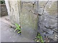
Old Milestone by Cotham Brow, Bristol Parish
Carved stone post by the UC road, in parish of BRISTOL (CITY OF BRISTOL District), Cotham Brow, just North of Fremantle Road, against wall of No 94, on East side of road. Bristol stone, erected by the Bristol turnpike trust in the 19th century.
Marked as a boundary stone on Old-maps 1882.
Inscription illegible.
Milestone Society National ID: GL_BRGL01.
Image: © M Faherty
Taken: 30 Mar 2014
0.02 miles
2
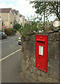
Postbox, Cotham Brow
Image: © Derek Harper
Taken: 15 Aug 2018
0.02 miles
3
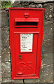
Postbox, Cotham Brow
Image: © Derek Harper
Taken: 15 Aug 2018
0.02 miles
4
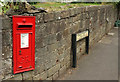
Postbox, Cotham Brow
Another angle on George V postbox BS6 298, also shown in Image] and Image], looking along Victoria Walk as the sign syas.
Image: © Derek Harper
Taken: 15 Aug 2018
0.02 miles
5
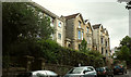
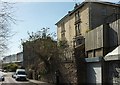
Houses on Cotham Brow
Quoins and gables on semis beside some modern infill - bomb damage, perhaps.
Image: © Derek Harper
Taken: 15 Aug 2018
0.02 miles
6
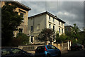
Houses on Victoria Walk, Bristol
Stately houses just off Cotham Brow.
Image: © Derek Harper
Taken: 15 Aug 2018
0.02 miles
7
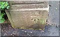
Ordnance Survey Cut Mark
This OS cut mark can be found on the gatepost of No67 Cotham Brow. It marks a point 55.196m above mean sea level.
Image: © Adrian Dust
Taken: 16 Jan 2020
0.03 miles
8
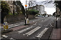
Bristol : Cotham Road
A road and zebra crossing.
Image: © Lewis Clarke
Taken: 24 Mar 2015
0.04 miles
9
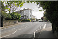
Cotham Brow
The top of the hill in a mature residential area.
Image: © Bill Boaden
Taken: 15 Apr 2017
0.05 miles
10
Fremantle Road, Bristol
Across the junction with Cotham Brow is the terrace shown in Image
Image: © Derek Harper
Taken: 20 Apr 2016
0.05 miles