IMAGES TAKEN NEAR TO
Kingsdown Parade, BRISTOL, BS6 5UE
Introduction
This page details the photographs taken nearby to Kingsdown Parade, BS6 5UE by members of the Geograph project.
The Geograph project started in 2005 with the aim of publishing, organising and preserving representative images for every square kilometre of Great Britain, Ireland and the Isle of Man.

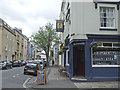
There are currently over 7.5m images from over14,400 individuals and you can help contribute to the project by visiting https://www.geograph.org.uk
Image Map
Images are licensed for reuse under creativecommons.org/licenses/by-sa/2.0
Notes
- Clicking on the map will re-center to the selected point.
- The higher the marker number, the further away the image location is from the centre of the postcode.
Image Listing (403 Images Found)
Images are licensed for reuse under creativecommons.org/licenses/by-sa/2.0
Image
Details
Distance
1
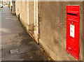
Postbox on Kingsdown Parade, Bristol
Elizabeth II postbox BS6 296 is on the wall of what should be number 17, Kingsdown Parade, but seems to be a garden. There was a school, Marlborough House School, here in the late C19; perhaps the building was destroyed in the war - or perhaps the last pupils trashed it!
Image: © Derek Harper
Taken: 4 Apr 2018
0.01 miles
2
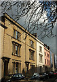
Listed buildings, Kingsdown Parade, Bristol
These can be seen in Image The two brown and one white facades are described at https://www.historicengland.org.uk/listing/the-list/list-entry/1202342 , as a terrace of three; the succeeding pair are at https://www.historicengland.org.uk/listing/the-list/list-entry/1209798 . The five are numbered 12, 12a, 12b, 12c, 12d Kingsdown Parade, presumably indicating something about historical ownership.
Image: © Derek Harper
Taken: 4 Apr 2018
0.01 miles
3
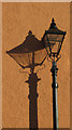
Lamppost, St Matthew's Road, Kingsdown
And its shadow, on the wall of a listed house behind The Ark.
Image: © Derek Harper
Taken: 4 Apr 2018
0.02 miles
4
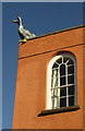
Geese on listed house, Kingsdown
You won't be surprised to learn that the geese do not feature in the listed building description https://www.historicengland.org.uk/listing/the-list/list-entry/1202534 . The "semicircular-arched second-floor sash" window does, however. This is the same wall as Image
Image: © Derek Harper
Taken: 4 Apr 2018
0.02 miles
5
Along Kingsdown Parade
With the Kingsdown Vaults on the corner.
Image: © Neil Owen
Taken: 25 Apr 2019
0.02 miles
6
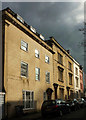
Kingsdown Parade, Bristol
Listed buildings on the southeast side of the road. First is number 14, early C19 https://www.historicengland.org.uk/listing/the-list/list-entry/1202343 ; then a slightly later terrace of three https://www.historicengland.org.uk/listing/the-list/list-entry/1202342 , succeeded by the attached pair described at https://www.historicengland.org.uk/listing/the-list/list-entry/1209798.
Image: © Derek Harper
Taken: 4 Apr 2018
0.02 miles
7
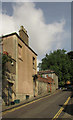
Marlborough Hill, Bristol
The top of the street, also shown from a different direction in Image the house on the left, which features the sculpture shown in Image, is listed and described at https://www.historicengland.org.uk/listing/the-list/list-entry/1202372 .
Image: © Derek Harper
Taken: 15 Jun 2018
0.02 miles
8
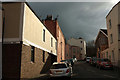
St Matthew's Road, Kingsdown
From the junction with Clevedon Terrace, and from where Image] was taken.
Image: © Derek Harper
Taken: 4 Apr 2018
0.02 miles
9
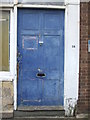
A door falling out of use
The boarding of windows are not a healthy sign, so the entrance looks more forlorn.
Image: © Neil Owen
Taken: 25 Apr 2019
0.02 miles
10
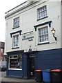
The Kingsdown Vaults
A fairly new pub - previously domestic residences until the twentieth century.
Image: © Neil Owen
Taken: 25 Apr 2019
0.02 miles