IMAGES TAKEN NEAR TO
St. Matthews Road, BRISTOL, BS6 5TU
Introduction
This page details the photographs taken nearby to St. Matthews Road, BS6 5TU by members of the Geograph project.
The Geograph project started in 2005 with the aim of publishing, organising and preserving representative images for every square kilometre of Great Britain, Ireland and the Isle of Man.

There are currently over 7.5m images from over14,400 individuals and you can help contribute to the project by visiting https://www.geograph.org.uk
Image Map
Images are licensed for reuse under creativecommons.org/licenses/by-sa/2.0
Notes
- Clicking on the map will re-center to the selected point.
- The higher the marker number, the further away the image location is from the centre of the postcode.
Image Listing (342 Images Found)
Images are licensed for reuse under creativecommons.org/licenses/by-sa/2.0
Image
Details
Distance
1
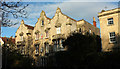
Houses on Cotham Road
This trio of houses with fancy gables are divided into flats. "An unusual picturesque silhouette to a standard attached house plan" https://www.historicengland.org.uk/listing/the-list/list-entry/1207757 .
Image: © Derek Harper
Taken: 4 Apr 2018
0.03 miles
2
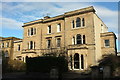
Houses on Cotham Road South
A villa divided into three, almost opposite the junction with Cotham Road.
Image: © Derek Harper
Taken: 4 Apr 2018
0.03 miles
3
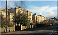
Houses on Cotham Road South
Image: © Derek Harper
Taken: 4 Apr 2018
0.03 miles
4
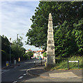
Southwest on Cotham Road at Cotham Park, Cotham, Bristol
Cotham Road swings west a few metres along. The shops in view are in Cotham Road South. The limestone obelisk is one of a pair at the turn in to Cotham Park.
A display in Bristol Museum and Art Gallery explains: "A pair of obelisks made of White Lias [limestone] with the upper surface of Cotham Marble used as naturally 'vermiculated' blocking. Many weathered blocks have had to be replaced with carved vermiculation." A closer look at Cotham Marble is Image The obelisks marked the entrance to Cotham Park, "developed by Francis and Richard Fry on the land of Cotham Lodge [after it was] demolished, 1846." They are listed Grade II: https://historicengland.org.uk/listing/the-list/list-entry/1207692
"White and Blue Lias Limestone
The muddy limestones from the top of the Triassic beds and bottom of the Jurassic are generally only used locally, on the outcrop – Horfield, Knowle, Cotham, Keynsham. Many of the beds tend not to weather well."
Image: © Robin Stott
Taken: 26 Jun 2017
0.04 miles
5
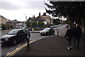
Bristol : Cotham Road
A road at the junction with Cotham Road South.
Image: © Lewis Clarke
Taken: 24 Mar 2015
0.04 miles
6
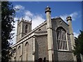
The church of St. Matthew and St. Nathanael
The foundation stone of the Church of St. Matthew, Kingsdown was laid on August 26th 1833. The eventual cost of the building was £7,882 and the Church was consecrated on April 23rd, 1835 by the Hon Henry Ryder, Bishop of Lichfield. Pevsner describes it as being typical early 19th. century with a long wide body, tall regular windows of three lights and four centred heads. There is a west tower in perpendicular style containing a peal of eight bells by Jeffries of Bristol.
Image: © Sharon Loxton
Taken: 2 Aug 2006
0.04 miles
8

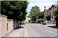
Victorian letterbox in Cotham Road South
Image: © Steve Daniels
Taken: 2 Jun 2011
0.04 miles
9
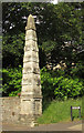
Obelisk, Cotham
One of a pair at the entrance to Cotham Park from Cotham Road. They are listed https://www.historicengland.org.uk/listing/the-list/list-entry/1207692 : "square, approx 10m high, with a small panelled plinth, and alternate bands of coursed stone and vermiculated blocks to a pyramidal top".
Image: © Derek Harper
Taken: 15 Jun 2018
0.04 miles
10
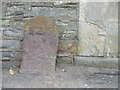
Boundary stone in St Matthew's Road
The original marks have all but faded now, but this stone would have marked the line of the parishes up until around WWII, after which the boundaries were changed.
Image: © Neil Owen
Taken: 25 Apr 2019
0.04 miles