IMAGES TAKEN NEAR TO
Fremantle Square, BRISTOL, BS6 5TN
Introduction
This page details the photographs taken nearby to Fremantle Square, BS6 5TN by members of the Geograph project.
The Geograph project started in 2005 with the aim of publishing, organising and preserving representative images for every square kilometre of Great Britain, Ireland and the Isle of Man.

There are currently over 7.5m images from over14,400 individuals and you can help contribute to the project by visiting https://www.geograph.org.uk
Image Map
Images are licensed for reuse under creativecommons.org/licenses/by-sa/2.0
Notes
- Clicking on the map will re-center to the selected point.
- The higher the marker number, the further away the image location is from the centre of the postcode.
Image Listing (399 Images Found)
Images are licensed for reuse under creativecommons.org/licenses/by-sa/2.0
Image
Details
Distance
1
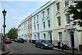
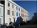
Listed buildings, Fremantle Square
On the northeast side of the square. The terrace of six is listed and described at https://www.historicengland.org.uk/listing/the-list/list-entry/1187179 : "c1830. By William Armstrong". The house beyond is listed separately https://www.historicengland.org.uk/listing/the-list/list-entry/1202229 .
Image: © Derek Harper
Taken: 10 Jun 2016
0.01 miles
2
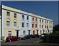
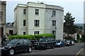
16-21 Fremantle Square, Bristol
The north-east side of this modest but attractive little early Victorian square (though it could pass for Georgian). By William Armstrong, c1841-42. The first-floor motif of windows recessed in blind arches is rare in Bristol, but common in London's Georgian houses. Grade II listed.
Image: © Stephen Richards
Taken: 23 May 2012
0.01 miles
3
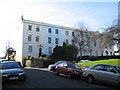
Fremantle square, South side
On a sunny February afternoon these terraced houses in the Kingsdown conservation area are an oasis of calm in the busy city of Bristol.
Image: © Dr Duncan Pepper
Taken: 9 Feb 2008
0.01 miles
4
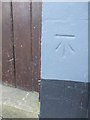
Benchmark at the top of Nine Tree Hill
A simple cutmark lies on a wall at the top of the hill, adjoining Fremantle Square. See https://www.bench-marks.org.uk/bm86482 for the entry in the Benchmark Database or Image] for a location view.
Image: © Neil Owen
Taken: 25 Apr 2019
0.02 miles
5

Ordnance Survey Cut Mark
This OS cut mark can be found on No22 Freemantle Square, at the top of Nine Tree Hill. It marks a point 48.832m above mean sea level.
Image: © Adrian Dust
Taken: 14 Mar 2020
0.02 miles
6
North East Terrace in Fremantle Square
In the Kingsdown conservation area of Bristol, these buildings painted in Italian ice cream colours make a pleasing addition to the built environment.
Image: © Dr Duncan Pepper
Taken: 9 Feb 2008
0.02 miles
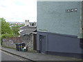
7
Attached houses, Nine Tree Hill, Bristol
Seen from the same spot as Image
Image: © Derek Harper
Taken: 10 Jun 2016
0.02 miles
8
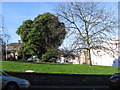
Fremantle Square Bristol
A pleasing green oasis of peace in the Kingsdown conservation area of Bristol.
Image: © Dr Duncan Pepper
Taken: 9 Feb 2008
0.02 miles
9
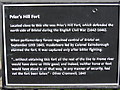
Plaque in Fremantle Square
At the top of Nine Tree Hill, on the edge of Kingsdown and overlooking the strategically important route from Bristol to the North is modern day Fremantle square, but in the English Civil War this was the location of an important fort, the plaque tells it all.
Image: © Dr Duncan Pepper
Taken: 1 Mar 2008
0.02 miles
10
Nine Tree Hill
Not sure exactly how many trees are here today, but there is certainly a benchmark on the wall - see Image
Image: © Neil Owen
Taken: 25 Apr 2019
0.02 miles