IMAGES TAKEN NEAR TO
Gibson Road, BRISTOL, BS6 5SG
Introduction
This page details the photographs taken nearby to Gibson Road, BS6 5SG by members of the Geograph project.
The Geograph project started in 2005 with the aim of publishing, organising and preserving representative images for every square kilometre of Great Britain, Ireland and the Isle of Man.

There are currently over 7.5m images from over14,400 individuals and you can help contribute to the project by visiting https://www.geograph.org.uk
Image Map
Images are licensed for reuse under creativecommons.org/licenses/by-sa/2.0
Notes
- Clicking on the map will re-center to the selected point.
- The higher the marker number, the further away the image location is from the centre of the postcode.
Image Listing (367 Images Found)
Images are licensed for reuse under creativecommons.org/licenses/by-sa/2.0
Image
Details
Distance
1
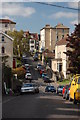
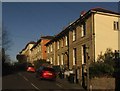
Sydenham Road, Cotham
Looking north-west along the road.
Image: © Trevor Harris
Taken: 26 Sep 2009
0.04 miles
2

Ordnance Survey Cut Mark
This OS cut mark can be found on the wall of Nos50 & 52 Arley Hill. It marks a point 38.228m above mean sea level.
Image: © Adrian Dust
Taken: 14 Mar 2020
0.04 miles
3
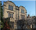
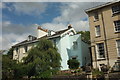
Houses on Sydenham Hill, Bristol
A pair of attached houses with interesting parapets.
Image: © Derek Harper
Taken: 29 Nov 2017
0.05 miles
4
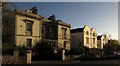
Houses on Sydenham Hill, Bristol
Attractive sets of houses on the northeast side of the road.
Image: © Derek Harper
Taken: 29 Nov 2017
0.05 miles
5
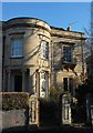
Listed houses, Sydenham Hill, Bristol
The full-height bow is shared between the pair of attached house, which are described at https://www.historicengland.org.uk/listing/the-list/list-entry/1202612 and date from 1879.
Image: © Derek Harper
Taken: 29 Nov 2017
0.05 miles
6
Houses on Sydenham Road, Bristol
Looking up the road seen on the left of Image All the buildings are listed; the nearest trio are described at https://www.historicengland.org.uk/listing/the-list/list-entry/1202613 , the next three at https://www.historicengland.org.uk/listing/the-list/list-entry/1282103 , and a further three at https://www.historicengland.org.uk/listing/the-list/list-entry/1202614 .
Image: © Derek Harper
Taken: 29 Nov 2017
0.06 miles
7

Ordnance Survey Cut Mark
This OS cut mark can be found on the gatepost between Nos7 & 9 Arley Hill. It marks a point 30.230m above mean sea level.
Image: © Adrian Dust
Taken: 14 Mar 2020
0.07 miles
8
Houses on Cotham Brow
A contrast of styles on the east side of the road between the junctions with Sydenham Road and Gibson Road.
Image: © Derek Harper
Taken: 15 Aug 2018
0.07 miles
9
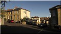
Junction, Nugent Hill, Bristol
Sydenham Road crosses the hill in slightly staggered fashion. The terrace of three houses on the left is listed https://www.historicengland.org.uk/listing/the-list/list-entry/1202613 . Beyond, Nugent Hill drops to meet Arley Hill.
Image: © Derek Harper
Taken: 29 Nov 2017
0.07 miles
10

Ordnance Survey Cut Mark
This OS cut mark can be found at the junction of Sydenham Road & Nugent Hill. It marks a point 40.785m above mean sea level.
Image: © Adrian Dust
Taken: 14 Mar 2020
0.07 miles