IMAGES TAKEN NEAR TO
Sydenham Road, BRISTOL, BS6 5SB
Introduction
This page details the photographs taken nearby to Sydenham Road, BS6 5SB by members of the Geograph project.
The Geograph project started in 2005 with the aim of publishing, organising and preserving representative images for every square kilometre of Great Britain, Ireland and the Isle of Man.

There are currently over 7.5m images from over14,400 individuals and you can help contribute to the project by visiting https://www.geograph.org.uk
Image Map
Images are licensed for reuse under creativecommons.org/licenses/by-sa/2.0
Notes
- Clicking on the map will re-center to the selected point.
- The higher the marker number, the further away the image location is from the centre of the postcode.
Image Listing (361 Images Found)
Images are licensed for reuse under creativecommons.org/licenses/by-sa/2.0
Image
Details
Distance
1
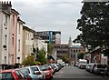
Sydenham Road, Bristol
With the striking graffiti at Stokes Croft showing beyond the end of the road.
Image: © Trevor Harris
Taken: 26 Sep 2009
0.01 miles
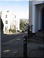
2
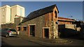
Zero, Sydenham Road, Bristol
This rather smart little wedge-shaped building, fitting in between Sydenham Road and Sydenham Lane, has, like the block of flats to the left Image], arrived too late to feature in a conventional numbering system, since number one is further up to the left. The name plate you can see by the door reads "Zero Sydenham Road". Technically, there could be room for more such buildings since Sydenham Road continues beyond the junction for another 40 metres before meeting Nine Tree Hill; would they have to be minus numbers?
Image: © Derek Harper
Taken: 29 Nov 2017
0.01 miles
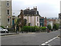
3
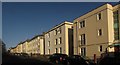
Sydenham Road, Bristol
The street shown in Image] from the opposite end. The modern block of flats on the right is Sydenham Place which, like the house shown in Image], doesn't get to fit into the street's numbering sequence.
Image: © Derek Harper
Taken: 29 Nov 2017
0.01 miles
4
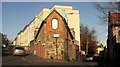
Zero, Sydenham Road, Bristol
The neat little corner house shown in Image], with Sydenham Road on the left and Sydenham Lane on the right.
Image: © Derek Harper
Taken: 29 Nov 2017
0.01 miles
5
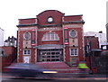
Metropolis, Cheltenham Road
The home of Jesters Comedy Club. It was built in 1914 in an Edwardian Baroque style as a cinema. It closed in 1955 and became a Christadelphian Hall or chapel. It was adapted for use as a bar under the name The Magic Box and now it has been refurbished as a new venue for Jesters Comedy Club
Image: © Eirian Evans
Taken: 7 Jan 2011
0.02 miles
6
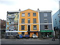
Elegance and style collide
Older buildings on Cheltenham Road show the original features along with the modern appreciation.
Image: © Neil Owen
Taken: 11 Oct 2022
0.02 miles
7
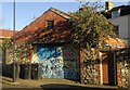
Garage, Sydenham Road, Bristol
With a graffiti-covereed door, this belongs to a house on Stokes Croft, but (see Image]) were it turned into a chic residence, it could feature as a minus number on Sydenham Road.
Image: © Derek Harper
Taken: 29 Nov 2017
0.03 miles
9
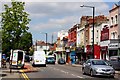
Nine Tree Hill Bristol
This charmingly named little street leads steeply up from the busy urban route of Stokes Croft to the peaceful charm of Freemantle square in the Kingsdown conservation area. The council, wisely, have made it a no through road.
Image: © Dr Duncan Pepper
Taken: 9 Feb 2008
0.03 miles
10
Kingsdown - Bristol's Vertical Suburb
The title is borrowed from a book about the area. Note the angle at which the child's pushchair is being pushed down Nine Tree Hill. Nearby I saw another woman using walking poles to get about.
Image: © HelenK
Taken: 4 May 2012
0.04 miles