IMAGES TAKEN NEAR TO
Wellington Lane, BRISTOL, BS6 5PY
Introduction
This page details the photographs taken nearby to Wellington Lane, BS6 5PY by members of the Geograph project.
The Geograph project started in 2005 with the aim of publishing, organising and preserving representative images for every square kilometre of Great Britain, Ireland and the Isle of Man.

There are currently over 7.5m images from over14,400 individuals and you can help contribute to the project by visiting https://www.geograph.org.uk
Image Map
Images are licensed for reuse under creativecommons.org/licenses/by-sa/2.0
Notes
- Clicking on the map will re-center to the selected point.
- The higher the marker number, the further away the image location is from the centre of the postcode.
Image Listing (293 Images Found)
Images are licensed for reuse under creativecommons.org/licenses/by-sa/2.0
Image
Details
Distance
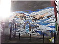
1
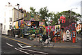
Bristol squat
This much decorated building, situated on the acute angle between Ashley Road and Richmond Road, has been occupied for several years by squatters.
Image: © Bob Jones
Taken: 17 Jul 2009
0.03 miles
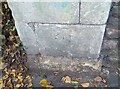
2
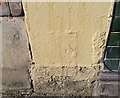
Ordnance Survey Cut Mark
This almost lost OS cut mark can be found on No26 Picton Street. It marks a point 21.382m above mean sea level.
Image: © Adrian Dust
Taken: 9 Oct 2021
0.04 miles
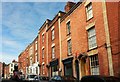
3
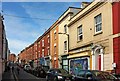
Picton Street, Bristol
"Picton Street is an unassuming little back street ... and it embodies all that is wonderful about Bristol." So says an article in Western Eye from 2011 at https://westerneye.net/life-style/2011/02/the-best-street-in-bristol-picton-street/ . The terrace, of 24 houses and dated 1816, is listed https://www.historicengland.org.uk/listing/the-list/list-entry/1208728 .
Image: © Derek Harper
Taken: 26 Jun 2017
0.04 miles
4
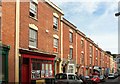
Picton Street, Bristol
The listed terrace https://www.historicengland.org.uk/listing/the-list/list-entry/1208728 shown from the other direction in Image "Some have C19 and C20 shop fronts, between party wall pilasters, with cornices and parapets of varying heights; doorways have pediments on brackets, fanlights and 6-panel doors; windows with 7 stepped voussoirs over 8/8-pane sashes."
Image: © Derek Harper
Taken: 26 Jun 2017
0.04 miles
5
In Memoriam
Moving tribute to a father on a wall at Picton Mews
Image: © Eirian Evans
Taken: 20 Feb 2018
0.04 miles
6
Gates on Ashley Road giving access to Wellington Lane houses
There is an OS benchmark Image on the second stone above the pavement on the jamb to the right of the white gate carrying the graffiti head
Image: © Roger Templeman
Taken: 4 Feb 2018
0.04 miles
7
Picton Street, Bristol
Looking in the other direction from where Image] was taken, along the south-western end of the same terrace https://www.historicengland.org.uk/listing/the-list/list-entry/1208728 . The sign on the white shopfront indicates a yoga centre.
Image: © Derek Harper
Taken: 26 Jun 2017
0.04 miles
8
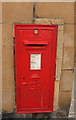
Postbox, Picton Street, Bristol
A closer view of the George V postbox BS6 308 shown in Image], which also gives an opportunity to admire the limestone ashlar of the old gaol https://www.historicengland.org.uk/listing/the-list/list-entry/1208783 .
Image: © Derek Harper
Taken: 26 Jun 2017
0.05 miles
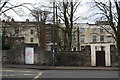
9
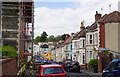
Wellington Avenue
A residential road leading from St Paul's to Montpelier.
Image: © Bill Boaden
Taken: 15 Apr 2017
0.05 miles
10
Ordnance Survey Cut Mark
This OS cut mark can be found on the gatepost of No65 Ashley Road. It marks a point 23.387m above mean sea level.
Image: © Adrian Dust
Taken: 9 Oct 2021
0.05 miles