IMAGES TAKEN NEAR TO
Arley Park, BRISTOL, BS6 5PL
Introduction
This page details the photographs taken nearby to Arley Park, BS6 5PL by members of the Geograph project.
The Geograph project started in 2005 with the aim of publishing, organising and preserving representative images for every square kilometre of Great Britain, Ireland and the Isle of Man.

There are currently over 7.5m images from over14,400 individuals and you can help contribute to the project by visiting https://www.geograph.org.uk
Image Map
Images are licensed for reuse under creativecommons.org/licenses/by-sa/2.0
Notes
- Clicking on the map will re-center to the selected point.
- The higher the marker number, the further away the image location is from the centre of the postcode.
Image Listing (283 Images Found)
Images are licensed for reuse under creativecommons.org/licenses/by-sa/2.0
Image
Details
Distance
1
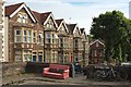
Sofa, Arley Park, Cotham
A sofa and some bikes either side of the steps linking Arley Park and Brookfield Road.
Image: © Derek Harper
Taken: 26 Jun 2017
0.01 miles
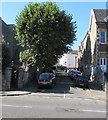
2
Arley Park, Cotham
Seen between houses that form end terraces on Arley Hill, and a no through road for traffic, blocked at the junction with Brookfield Lane.
Image: © Derek Harper
Taken: 29 Jul 2015
0.01 miles
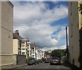
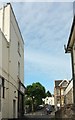
3
Brookfield Road, Bristol
Ascending from the A38 Cheltenham Road opposite Cheltenham Lane.
Image: © Jaggery
Taken: 13 Sep 2018
0.02 miles
4
Everest office, Cheltenham Road, Bristol
Everest Secretarial Services office on the left is at 195 Cheltenham Road on the corner of Brookfield Road.
Image: © Jaggery
Taken: 13 Sep 2018
0.04 miles
5
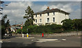
Houses on Cotham Brow /Arley Hill
The left half is on Cotham Brow, the right half on Arley Hill (right). The road on the extreme left at this mini-roundabout is Redland Road. Down Cotham Brow can be seen The Arches, the railway viaduct carrying the Severn Beach line to Montpelier station.
Image: © Derek Harper
Taken: 15 Aug 2018
0.04 miles
6
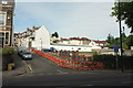
Vanished library, Winsley Road, Bristol
The empty site used to be occupied by Cheltenham Road library, which, alas, I never photographed before its demolition earlier this year. Images can be seen at http://www.bristolpost.co.uk/news/bristol-news/campaigners-take-over-closed-cheltenham-12086 . Developers are due to turn it into ... upmarket flats.
Image: © Derek Harper
Taken: 26 Jun 2017
0.04 miles
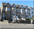
7
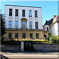
Three-storey building, 199 Cheltenham Road, Bristol
This could be a Georgian building, or a later building in the Georgian style.
Image: © Jaggery
Taken: 13 Sep 2018
0.05 miles
8
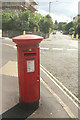
Postbox, Cotham Brow
A different cypher to Image], 200 metres further up Cotham Brow, this is Elizabeth II postbox BS6 243, also visible in Image In the background is the scaffolded house in Image
Image: © Derek Harper
Taken: 15 Aug 2018
0.05 miles
9
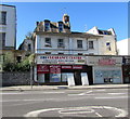
The Clearance Centre, 201 Cheltenham Road, Bristol
Viewed across the A38 from the corner of Station Road.
Image: © Jaggery
Taken: 13 Sep 2018
0.05 miles
10
Cheltenham Lane meets Cheltenham Road, Bristol
A cyclist passes along the A38 where this little cul-de-sac emerges. On the other side is Brookfield Road. On the corner on the left is RePlay, a bar with lots of games.
Image: © Derek Harper
Taken: 26 Jun 2017
0.05 miles