IMAGES TAKEN NEAR TO
Ashley Road, BRISTOL, BS6 5NR
Introduction
This page details the photographs taken nearby to Ashley Road, BS6 5NR by members of the Geograph project.
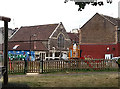
The Geograph project started in 2005 with the aim of publishing, organising and preserving representative images for every square kilometre of Great Britain, Ireland and the Isle of Man.

There are currently over 7.5m images from over14,400 individuals and you can help contribute to the project by visiting https://www.geograph.org.uk
Image Map
Images are licensed for reuse under creativecommons.org/licenses/by-sa/2.0
Notes
- Clicking on the map will re-center to the selected point.
- The higher the marker number, the further away the image location is from the centre of the postcode.
Image Listing (166 Images Found)
Images are licensed for reuse under creativecommons.org/licenses/by-sa/2.0
Image
Details
Distance
1
Electricity vent on Ashley Road
An underground substation has to bring fresh, cool air into the chambers.
Image: © Neil Owen
Taken: 11 Oct 2022
0.07 miles
2
Albert Park
Seen from Ashley Road. Graffiti seems to be a popular artform in the Montpelier and St.Pauls areas of Bristol though quite why a camel wearing a spacesuit would be asking Ou'est Lemac? is quite beyond me!
Image: © Martin Addison
Taken: 25 Jun 2011
0.07 miles
3
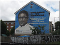
Welcome to St Paul's mural
On the end of a row of houses on City Road, this is one of many murals in this area of Bristol, mainly originating from the West Indian community. It depicts the Hon. Owen Henry.
Image: © Stephen Craven
Taken: 25 Jun 2017
0.08 miles
4
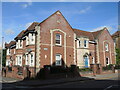
Osbourne Court
A Bristol Churches Housing Association development, named after Olive Osbourne, B.E.M. She also opened the houses 9th July, 1993. It won a civic award at that time.
Image: © Neil Owen
Taken: 11 Oct 2022
0.09 miles
5
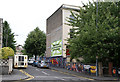
The Albany Centre, Shaftesbury Avenue
A community theatre company is now based in this former Methodist Church.
Image: © Stephen Craven
Taken: 27 Jun 2017
0.09 miles
6
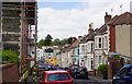
Wellington Avenue
A residential road leading from St Paul's to Montpelier.
Image: © Bill Boaden
Taken: 15 Apr 2017
0.10 miles
7
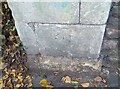
Ordnance Survey Cut Mark
This OS cut mark can be found on the gatepost of No65 Ashley Road. It marks a point 23.387m above mean sea level.
Image: © Adrian Dust
Taken: 9 Oct 2021
0.10 miles
8
Upper Cheltenham Place, Montpelier, Bristol
The name suggests an exclusive crescent of Regency houses. The reality is somewhat different.
Image: © Stephen Craven
Taken: 27 Jun 2017
0.10 miles
9
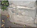
Ordnance Survey Cut Mark
This OS cut mark can be found on gatepost of No119 Ashley Road. It marks a point 15.685m above mean sea level.
Image: © Adrian Dust
Taken: 9 Oct 2021
0.10 miles
10
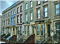
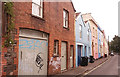
Large terrace houses
City Road, Bristol
Image: © Anthony O'Neil
Taken: 3 Feb 2023
0.11 miles