IMAGES TAKEN NEAR TO
Lower Cheltenham Place, BRISTOL, BS6 5LA
Introduction
This page details the photographs taken nearby to Lower Cheltenham Place, BS6 5LA by members of the Geograph project.
The Geograph project started in 2005 with the aim of publishing, organising and preserving representative images for every square kilometre of Great Britain, Ireland and the Isle of Man.

There are currently over 7.5m images from over14,400 individuals and you can help contribute to the project by visiting https://www.geograph.org.uk
Image Map
Images are licensed for reuse under creativecommons.org/licenses/by-sa/2.0
Notes
- Clicking on the map will re-center to the selected point.
- The higher the marker number, the further away the image location is from the centre of the postcode.
Image Listing (109 Images Found)
Images are licensed for reuse under creativecommons.org/licenses/by-sa/2.0
Image
Details
Distance
1
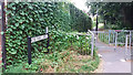
Rosa Parks Lane, off Brook Road, Bristol
Rosa Parks was a famous black rights activist in the USA, so an obvious choice for naming a street in a part of Bristol with a large West Indian community.
Image: © Stephen Craven
Taken: 27 Jun 2017
0.03 miles
2
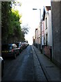
Cobourg Road, Montpelier
A very narrow Montpelier street, effectively built into the side of a hill.
Image: © George Evans
Taken: 6 Dec 2008
0.03 miles
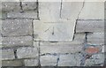
3
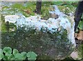
Ordnance Survey Rivet
This damaged OS rivet can be found on the low wall of No13 Cobourg Road. It marks a point 28.087m above mean sea level.
Image: © Adrian Dust
Taken: 9 Oct 2021
0.03 miles
4
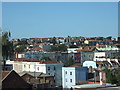
View over Montpelier, Bristol
This view over the rooftops of the Montpelier district was taken from the upper floor of the Pierian Centre, a house on the northern side of Portland Square, St Paul's, on the English Heritage Open Day, 2009.
Image: © C P Smith
Taken: 12 Sep 2009
0.04 miles
5
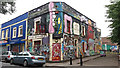
The former Star and Garter, Brook Road, Bristol
A closed pub, now used as a practice area for street artists.
Image: © Stephen Craven
Taken: 27 Jun 2017
0.04 miles
7
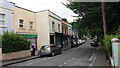
Brook Road, Bristol
Part of the St Paul's district.
Image: © Stephen Craven
Taken: 27 Jun 2017
0.05 miles
8
Ordnance Survey Cut Mark
This OS cut mark can be found on No137 York Road. It marks a point 40.047m above mean sea level.
Image: © Adrian Dust
Taken: 9 Oct 2021
0.07 miles
9
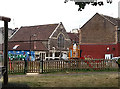
The Albany Centre, Shaftesbury Avenue
A community theatre company is now based in this former Methodist Church.
Image: © Stephen Craven
Taken: 27 Jun 2017
0.07 miles
10
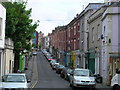
Picton Street
Picton Street, Montpelier, Bristol
Image: © Kate Lambert
Taken: 1 May 2005
0.07 miles