IMAGES TAKEN NEAR TO
Upper Cheltenham Place, BRISTOL, BS6 5HR
Introduction
This page details the photographs taken nearby to Upper Cheltenham Place, BS6 5HR by members of the Geograph project.
The Geograph project started in 2005 with the aim of publishing, organising and preserving representative images for every square kilometre of Great Britain, Ireland and the Isle of Man.

There are currently over 7.5m images from over14,400 individuals and you can help contribute to the project by visiting https://www.geograph.org.uk
Image Map
Images are licensed for reuse under creativecommons.org/licenses/by-sa/2.0
Notes
- Clicking on the map will re-center to the selected point.
- The higher the marker number, the further away the image location is from the centre of the postcode.
Image Listing (158 Images Found)
Images are licensed for reuse under creativecommons.org/licenses/by-sa/2.0
Image
Details
Distance
1
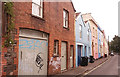
Upper Cheltenham Place, Montpelier, Bristol
The name suggests an exclusive crescent of Regency houses. The reality is somewhat different.
Image: © Stephen Craven
Taken: 27 Jun 2017
0.02 miles
2
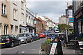
Upper Cheltenham Place
A fairly hilly suburb. York Road branches off to the left.
Image: © Bill Boaden
Taken: 15 Apr 2017
0.08 miles
3
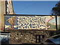
Herberts Bakery art
Next to a popular local shop in Wellington Avenue, Montpelier.
Image: © George Evans
Taken: 6 Dec 2008
0.08 miles
4
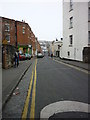
Picton Street, Montpelier
Taken from where it meets Ashley Road, this is Picton Street where I lived for fifteen happy years back in the 1980s and 1990s. And Henry Irving lived there too, in the white stuccoed house in the foreground on the right. As did Cary Grant for short period when he was a boy (same side, further down). This is the last remaining Georgian shopping street in Bristol and there are still some shops and businesses further down (Licata's deli and Herbert's bakery being the best and longest-standing), though not nearly many as when I lived there, sad to say.
Image: © Carroll Pierce
Taken: 12 Mar 2012
0.08 miles
5
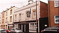
The Beaufort pub, York Road, Bristol
Image: © Stephen Craven
Taken: 27 Jun 2017
0.08 miles
6
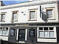
The Beaufort
A little boozer on York Road. See Image] for the sign outside.
Image: © Neil Owen
Taken: 11 Oct 2022
0.08 miles
7
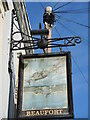
Beaufort pub sign
The little sidestreet boozer has a hand-created sign outside. Students of the local aerospace industries will associate Bristol with the Beaufort - a twin engined torpedo bomber, introduced into service at the start of WWII.
Image: © Neil Owen
Taken: 11 Oct 2022
0.08 miles
8
The Albany Centre, Shaftesbury Avenue
A community theatre company is now based in this former Methodist Church.
Image: © Stephen Craven
Taken: 27 Jun 2017
0.09 miles
9
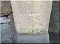
Ordnance Survey Cut Mark
This OS cut mark can be found on the gatepost of No104 Richmond Road. It marks a point 43.041m above mean sea level.
Image: © Adrian Dust
Taken: 9 Oct 2021
0.09 miles
10
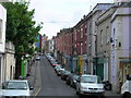
Picton Street
Picton Street, Montpelier, Bristol
Image: © Kate Lambert
Taken: 1 May 2005
0.09 miles