IMAGES TAKEN NEAR TO
Sommerville Road South, BRISTOL, BS6 5DT
Introduction
This page details the photographs taken nearby to Sommerville Road South, BS6 5DT by members of the Geograph project.
The Geograph project started in 2005 with the aim of publishing, organising and preserving representative images for every square kilometre of Great Britain, Ireland and the Isle of Man.

There are currently over 7.5m images from over14,400 individuals and you can help contribute to the project by visiting https://www.geograph.org.uk
Image Map
Images are licensed for reuse under creativecommons.org/licenses/by-sa/2.0
Notes
- Clicking on the map will re-center to the selected point.
- The higher the marker number, the further away the image location is from the centre of the postcode.
Image Listing (117 Images Found)
Images are licensed for reuse under creativecommons.org/licenses/by-sa/2.0
Image
Details
Distance
1
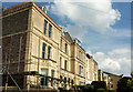
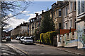
Ashley Court Road, Bristol
An impressive terrace of five that seems to occupy the site of the lost Ashley Court, and seen from the junction with Sommerville Road South.
Image: © Derek Harper
Taken: 7 May 2019
0.03 miles
2
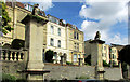
Pillars, Ashley Court
"Pair of gate piers to the lost house of Ashley Court. Early to mid-18th century. Bath Stone ... Tall piers, c.6 m. high, with rusticated plinths, smooth ashlar upper section with cap. Later, Victorian, additions comprise the incised inscription of ASHLEY COURT, and the cartouche-bearing lions placed on top ... these gate piers relate to a lost house, owned by the Hooke family in the mid-18th century. The site of the house was redeveloped with suburban housing in the mid-19th century, leaving these extremely large piers as relics of the former elaborate garden layout ... " https://historicengland.org.uk/listing/the-list/list-entry/1096047 . Behind them is the terrace shown in Image
Image: © Derek Harper
Taken: 7 May 2019
0.04 miles
3
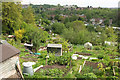
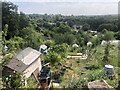
Ashley Vale Allotments
A further view from Ashley Hill of the allotments shown in Image], and Ashley Vale. The prominent terrace on the right is on Mina Road.
Image: © Derek Harper
Taken: 7 May 2019
0.04 miles
4
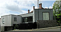
House on Sommerville Road South, Bristol
A 2015 house that won the 2016 Daily Telegraph Home Building & Renovating Award for Most Inspiring Home http://media.rightmove.co.uk/24k/23297/65567774/23297_7673042_DOC_02_0000.pdf .
Image: © Derek Harper
Taken: 7 May 2019
0.04 miles
6
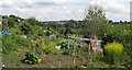
Ashley Vale Allotments
Looking to the left from Image In the distance is the BT mast on Pur Down https://www.geograph.org.uk/search.php?i=108230953 .
Image: © Derek Harper
Taken: 7 May 2019
0.06 miles
7
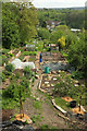
Ashley Vale Allotments
The western corner of the allotments shown in https://www.geograph.org.uk/search.php?i=108232949 , seen from Ashley Hill. Houses on Mina Road are below.
Image: © Derek Harper
Taken: 7 May 2019
0.07 miles
8
Bristol : Hurlingham Road
A small road heading up the hill.
Image: © Lewis Clarke
Taken: 24 Mar 2015
0.08 miles
9
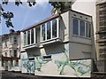
Mural, Hurlingham Road, Bristol
This is on a house near Ashley Hill.
Image: © Derek Harper
Taken: 28 May 2015
0.08 miles
10
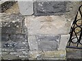
Ordnance Survey Cut Mark
This OS cut mark can be found on the gatepost of No1 Walsingham Road. It marks a point 53.388m above mean sea level.
Image: © Adrian Dust
Taken: 1 Jul 2022
0.08 miles