IMAGES TAKEN NEAR TO
Chesterfield Road, BRISTOL, BS6 5DP
Introduction
This page details the photographs taken nearby to Chesterfield Road, BS6 5DP by members of the Geograph project.
The Geograph project started in 2005 with the aim of publishing, organising and preserving representative images for every square kilometre of Great Britain, Ireland and the Isle of Man.

There are currently over 7.5m images from over14,400 individuals and you can help contribute to the project by visiting https://www.geograph.org.uk
Image Map
Images are licensed for reuse under creativecommons.org/licenses/by-sa/2.0
Notes
- Clicking on the map will re-center to the selected point.
- The higher the marker number, the further away the image location is from the centre of the postcode.
Image Listing (177 Images Found)
Images are licensed for reuse under creativecommons.org/licenses/by-sa/2.0
Image
Details
Distance
1
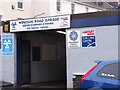
Windsor Road Garage, St Andrew's, Bristol
Family run business tucked away in St Andrew's
Image: © Eirian Evans
Taken: 13 Oct 2014
0.01 miles
2
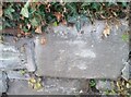
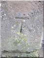
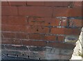
Ordnance Survey Cut Mark
This OS cut mark can be found on the wall of No76 Chesterfield Road. It marks a point 55.705m above mean sea level.
Image: © Adrian Dust
Taken: 9 Oct 2021
0.05 miles
3
Bristol : Saint Andrews Road
A small residential road off of Cromwell Road.
Image: © Lewis Clarke
Taken: 24 Mar 2015
0.07 miles
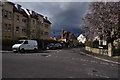
4
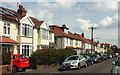
Balmoral Road, Bristol
Semis along the road shown in Image
Image: © Derek Harper
Taken: 7 May 2019
0.07 miles
5
Ordnance Survey Cut Mark
This OS cut mark can be found on the gatepost of No109 Cromwell Road. It marks a point 57.309m above mean sea level.
Image: © Adrian Dust
Taken: 3 Mar 2016
0.09 miles
6
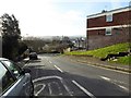
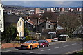
St Andrew's Hill
Looking south to Montpelier
Image: © Eirian Evans
Taken: 20 Feb 2018
0.09 miles
7
Bristol : Balmoral Road
A road heading off from Hurlingham Road.
Image: © Lewis Clarke
Taken: 24 Mar 2015
0.09 miles
8
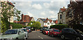
Balmoral Road, Bristol
A similar view to Image, looking around the corner a little more.
Image: © Derek Harper
Taken: 7 May 2019
0.09 miles
9
Ordnance Survey Cut Mark
This OS cut mark can be found on No118 St Andrews Road. It marks a point 48.975m above mean sea level.
Image: © Adrian Dust
Taken: 9 Oct 2021
0.10 miles
10
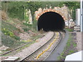
Railway tunnel at Montpelier station
Image: © Dr Duncan Pepper
Taken: 28 Nov 2008
0.10 miles