IMAGES TAKEN NEAR TO
The Maltings, Fairlawn Road, BRISTOL, BS6 5BB
Introduction
This page details the photographs taken nearby to The Maltings, Fairlawn Road, BS6 5BB by members of the Geograph project.
The Geograph project started in 2005 with the aim of publishing, organising and preserving representative images for every square kilometre of Great Britain, Ireland and the Isle of Man.

There are currently over 7.5m images from over14,400 individuals and you can help contribute to the project by visiting https://www.geograph.org.uk
Image Map
Images are licensed for reuse under creativecommons.org/licenses/by-sa/2.0
Notes
- Clicking on the map will re-center to the selected point.
- The higher the marker number, the further away the image location is from the centre of the postcode.
Image Listing (114 Images Found)
Images are licensed for reuse under creativecommons.org/licenses/by-sa/2.0
Image
Details
Distance
1
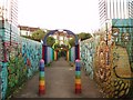
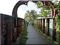
Rainbow foot bridge
The foot bridge crosses the Severn Beach railway not far to the east of Montpelier station. It connects Fairlawn road to the south with Hurlingham road to the north.
Image: © Sharon Loxton
Taken: 7 Jul 2006
0.03 miles
2
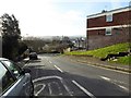
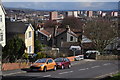
St Andrew's Hill
Looking south to Montpelier
Image: © Eirian Evans
Taken: 20 Feb 2018
0.04 miles
3
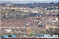
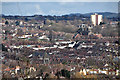
Bristol : City Scenery
Looking out across the rooftops and suburbs of Bristol.
Image: © Lewis Clarke
Taken: 24 Mar 2015
0.04 miles
4
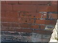
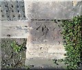
Ordnance Survey Cut Mark
This OS cut mark can be found on No118 St Andrews Road. It marks a point 48.975m above mean sea level.
Image: © Adrian Dust
Taken: 9 Oct 2021
0.05 miles
5
Rainbow bridge
Footbridge over the railway connecting Hurlingham Road and Fairlawn Road
Image: © Eirian Evans
Taken: 18 Sep 2015
0.05 miles
6
Bristol : City Scenery
From Balmoral Road looking out across the city skyline.
Image: © Lewis Clarke
Taken: 24 Mar 2015
0.05 miles
7
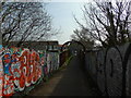
The Rainbow Bridge
Taken at the St Andrews end, this is what is locally known as the Rainbow Bridge spanning the Temple Meads to Severn Beach railway line at Montpelier, Bristol. Fairfield High School is at the Montpelier end.
Image: © Carroll Pierce
Taken: 26 Mar 2017
0.05 miles
8
Bristol : Saint Andrews Road
A small residential road off of Cromwell Road.
Image: © Lewis Clarke
Taken: 24 Mar 2015
0.06 miles
9
Ordnance Survey Cut Mark
This OS cut mark can be found at the entrance to Field House on Richmond Road. It marks a point 146ft above mean sea level.
Image: © Adrian Dust
Taken: 9 Oct 2021
0.06 miles
10
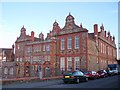
Fairfield School, Montpelier, Bristol.
The school, situated in Fairlawn Road, Montpelier, began life in 1898 as Fairfield Secondary and Higher Grade School. It was accorded grammar school status in 1945, after the 1944 Education Act. In Easter 2006 the site was replaced with a new school in a different location as this building only had capacity for 500 pupils, which was deemed insufficient.
Image: © Sharon Loxton
Taken: 7 Jul 2006
0.06 miles